
Jie Shan – författare
710 kr
Skickas inom 10-15 vardagar

673 kr
Läs direkt efter köp
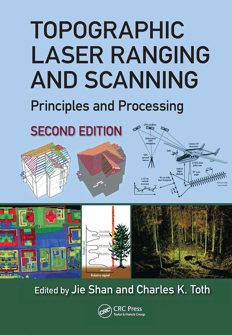
Topographic Laser Ranging and Scanning, Second Edition, provides a comprehensive discussion of topographic LiDAR principles, systems, data acquisition, and data processing techniques. This edition presents an introduction and summary of various LiDAR systems and their principles and addresses the operational principles of the different components and ranging methods of LiDAR systems. It discusses the subsequent geometric processing of LiDAR data, with particular attention to quality, accuracy, and meeting standards and addresses the theories and practices of information extraction from LiDAR data, including terrain surface generation, forest inventory, orthoimage generation, building reconstruction, and road extraction.
Written by leaders in the field, this comprehensive compilation is a must-have reference book for senior undergraduate and graduate students majoring or working in diverse disciplines, such as geomatics, geodesy, natural resources, urban planning, computer vision, and computer graphics. It is also vital resource for researchers who are interested in developing new methods and need in-depth knowledge of laser scanning and data processing and other professionals may gain the same from the broad topics addressed in this book.
New in the Second Edition:
A comprehensive array of new laser ranging and scanning technologies.
Developments in LiDAR data format and processing techniques.
Regrouping of surface modeling, representations and reconstruction.
Enhanced discussions on the principles and fundamentals beyond small-footprint pulsed laser systems and new application examples.
Many new examples and illustrations.
1 622 kr
Skickas inom 10-15 vardagar
2 049 kr
Läs direkt efter köp
Earth Observation interacts with space, remote sensing, communication, and information technologies, and plays an increasingly significant role in Earth related scientific studies, resource management, homeland security, topographic mapping, and development of a healthy, sustainable environment and community.
Geospatial Technology for Earth Observation provides an in-depth and broad collection of recent progress in Earth observation. Contributed by leading experts in this field, the book covers satellite, airborne and ground remote sensing systems and system integration, sensor orientation, remote sensing physics, image classification and analysis, information extraction, geospatial service, and various application topics, including cadastral mapping, land use change evaluation, water environment monitoring, flood mapping, and decision making support.
Geospatial Technology for Earth Observation serves as a valuable training source for researchers, developers, and practitioners in geospatial science and technology industry. It is also suitable as a reference book for upper level college students and graduate students in geospatial technology, geosciences, resource management, and informatics.

1 622 kr
Skickas inom 10-15 vardagar
3 310 kr
Skickas inom 10-15 vardagar

673 kr
Läs direkt efter köp
Topographic Laser Ranging and Scanning, Second Edition, provides a comprehensive discussion of topographic LiDAR principles, systems, data acquisition, and data processing techniques. This edition presents an introduction and summary of various LiDAR systems and their principles and addresses the operational principles of the different components and ranging methods of LiDAR systems. It discusses the subsequent geometric processing of LiDAR data, with particular attention to quality, accuracy, and meeting standards and addresses the theories and practices of information extraction from LiDAR data, including terrain surface generation, forest inventory, orthoimage generation, building reconstruction, and road extraction.
Written by leaders in the field, this comprehensive compilation is a must-have reference book for senior undergraduate and graduate students majoring or working in diverse disciplines, such as geomatics, geodesy, natural resources, urban planning, computer vision, and computer graphics. It is also vital resource for researchers who are interested in developing new methods and need in-depth knowledge of laser scanning and data processing and other professionals may gain the same from the broad topics addressed in this book.
New in the Second Edition:
A comprehensive array of new laser ranging and scanning technologies.
Developments in LiDAR data format and processing techniques.
Regrouping of surface modeling, representations and reconstruction.
Enhanced discussions on the principles and fundamentals beyond small-footprint pulsed laser systems and new application examples.
Many new examples and illustrations.