
Martin Schempp – författare
Visar alla böcker från författaren . Handla med fri frakt och snabb leverans.
17 produkter
17 produkter

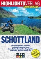
Häftad, Tyska
182 kr
Skickas inom 3-6 vardagar

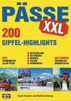
Häftad, Tyska
182 kr
Skickas inom 3-6 vardagar
Häftad, Tyska, 2023
182 kr
Skickas inom 3-6 vardagar
Häftad, Tyska, 2021
237 kr
Skickas inom 3-6 vardagar

Del 2 - Alternativer Beobachter
Alternativer Beobachter: Operation Zitadelle geglückt!
Inbunden, Tyska, 2019
186 kr
Skickas inom 3-6 vardagar

Del 3 - Alternativer Beobachter
Alternativer Beobachter: Unternehmen Seelöwe hat begonnen!
Inbunden, Tyska, 2020
186 kr
Skickas inom 3-6 vardagar

Del 4 - Alternativer Beobachter
Alternativer Beobachter: Stalingrad
Inbunden, Tyska, 2021
221 kr
Skickas inom 3-6 vardagar

Häftad, Tyska
350 kr
Skickas inom 3-6 vardagar

Häftad, Tyska
290 kr
Skickas inom 3-6 vardagar
195 kr
Skickas inom 3-6 vardagar
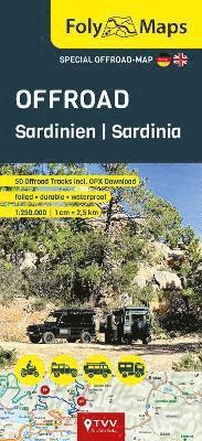
Discover the off-road fascination of Sardinia withthe FolyMap Special Off-Road Sardinia map - your indispensable guide foradventurous off-road driving. Designedspecifically for this region, the map offers over 60 selected off-road routes,each marked and accompanied by useful basic information and a QR code. A scan of the QR code reveals detailed route descriptions and the GPXdownload to the track. This laminated map is robust, weather and tearresistant, and can be written on, making it ideal for your notes and plans. Itshandy format and precise cartography make it a must-have for off-roadtravellers who want to explore the wild and sometimes spectacular trails inSardinia. The features of the FolyMap Offroad Sardinia at a glance:* over 60 marked off-road tracks * basic information such as difficulty level and length for each track* laminated* durable* weatherproof* scale 1:250,000* clear cartography Discover the world of FolyMaps Offroad Special Maps - your indispensablecompanion for extraordinary off-road adventures. This special series focuses onthe best off-road regions in Europe and each features over 50 carefullyselected off-road trails in the respective region. Each trail is marked on themap and is supplemented by basic information in bullet points and a practicalQR code. Scan the QR code for detailed route descriptions and a GPX downloadfor each route. The FolyMap Offroad special maps are robust, weatherproof, tear-resistantand writable - ideal for noting your discoveries and plans. With a handy formatand precise cartography, these maps are perfect for any off-road enthusiast whovalues quality, reliability and discovering adventurous trails.
191 kr
Skickas inom 3-6 vardagar
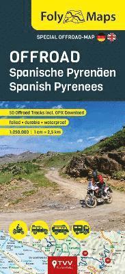
Discover the off-road fascination of the SpanishPyrenees with the FolyMap Special Map Off-Road Spanish Pyrenees - yourindispensable guide for adventurous off-road driving. Designed specifically for this region, the mapoffers over 60 selected off-road routes, each marked and accompanied by usefulbasic information and a QR code. A scan ofthe QR code reveals detailed route descriptions and the GPX download to thetrack. This laminated map is robust, weather and tear resistant, and can bewritten on, making it ideal for your notes and plans. Its handy format andprecise cartography make it a must-have for off-road travellers who want toexplore the wild and sometimes spectacular trails of the Spanish Pyrenees. The features of the FolyMap Offroad Spanish Pyrenees at a glance:* over 60 marked off-road tracks * basic information such as difficulty level and length for each track* laminated* durable* weatherproof* scale 1:250,000* clear cartography Discover the world of FolyMaps Offroad Special Maps - your indispensablecompanion for extraordinary off-road adventures. This special series focuses onthe best off-road regions in Europe and each features over 50 carefullyselected off-road trails in the respective region. Each trail is marked on themap and is supplemented by basic information in bullet points and a practicalQR code. Scan the QR code for detailed route descriptions and a GPX downloadfor each route. The FolyMap Offroad special maps are robust, weatherproof, tear-resistantand writable - ideal for noting your discoveries and plans. With a handy formatand precise cartography, these maps are perfect for any off-road enthusiast whovalues quality, reliability and discovering adventurous trails.
195 kr
Skickas inom 3-6 vardagar
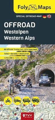
Discover the off-road fascination of the WesternAlps with the FolyMap special map Off-Road Western Alps - your indispensableguide for adventurous off-road driving. Designedspecifically for this region, the map offers 60 selected off-road tracks, eachmarked and accompanied by useful basic information and a QR code. A scan of the QR code reveals detailed route descriptions and the GPXdownload for the track. This laminated map is robust, weather and tearresistant, and can be written on, making it ideal for your notes and plans. Itshandy format and precise cartography make it a must-have for off-road fans whowant to explore the wild and sometimes spectacular trails of the Western Alps. The features of the FolyMap Offroad Western Alps at a glance:- 60 marked off-road slopes - Basic information such as difficulty and length for each slope- laminated- durable- weatherproof- Scale 1:250,000- Clear cartography Discover the world of FolyMaps Offroad Special Maps - your indispensablecompanion for extraordinary off-road adventures. This special series focuses onthe best off-road regions in Europe and each features over 50 carefullyselected off-road trails in the respective region. Each trail is marked on themap and is supplemented by basic information in bullet points and a practicalQR code. Scan the QR code for detailed route descriptions and a GPX downloadfor each route. The FolyMap Offroad special maps are robust, weatherproof,tear-resistant and writable - ideal for noting your discoveries and plans. Witha handy format and precise cartography, these maps are perfect for any off-roadenthusiast who values quality, reliability and discovering adventurous trails.
Häftad, Engelska, 2025
579 kr
Skickas
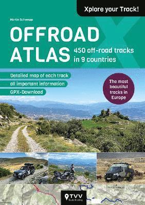
This Offroad Atlas presents 450 off-road routes withimportant information, brief descriptions and pictures. By popular demand,there is now also information on suitability for different vehicle classes. The features and countries at a glance:450 routes. Over 150 new and updated routes in this editionThere is a map for each off-road route* Detailed and informative route descriptions* Suitability classification by vehicle type* Information on the difficulty level and altitude profile of each route* Some routes are illustrated with photos* GPX tracks for each off-road route, easily downloadable via QR code Discover routes in the following countries: * Germany * Austria *Slovenia * Croatia * Montenegro * Albania * Italy (Northern Italy) * France(Western Alps and Pyrenees) * Spain (Pyrenees and Northern Spain). There aremany off-road routes in Europe that are legally accessible. Whether you are travelling on a dual-sport bike, an off-road vehicle oran expedition vehicle, our Offroad Atlas is guaranteed to contain the rightoff-road route for your individual tours. Our scouts have tested and, of course, tracked the most interestingoff-road routes in Europe for you. If you are looking for exciting routes andscenic highlights for your next off-road tour, you will find them in ourOffroad Atlas. The Offroad Atlas is interactive! The integrated QR code for each tour, which allows direct access to GPXdata, makes the atlas interactive. This makes it easy to download tracks,follow them and even add your own comments. The atlas also offers aninteractive platform where off-roaders can share their experiences and use tipsfrom other travellers. This is how current information about track conditionsor new closures can be exchanged.

Häftad, Tyska
255 kr
Skickas inom 3-6 vardagar
Häftad, Tyska, 2025
492 kr
Skickas inom 3-6 vardagar

Häftad, Engelska, 2026
450 kr
Kommande
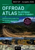
The 2027 Edition of the Offroad Atlas presents 450 off-road routes with important information, brief descriptions and pictures. By popular demand, there is now also information on suitability for different vehicle classes.The features and countries at a glance:450 routesOver 200 new and updated routes in this editionThere is a map for each off-road route* Detailed and informative route descriptions* New: Suitability classification by vehicle type* Information on the difficulty level and altitude profile of each route* Some routes are illustrated with photos* GPX tracks for each off-road route, easily downloadable via QR codeDiscover routes in the following countries:* Denmark* Norway* Sweden* Finland* Germany* Austria* Slovenia* Croatia* Bosnia and Herzegowina* Montenegro* Albania* Italy * Switzerland* France (Western Alps)* SpainThere are many off-road routes in Europe that are legally accessible.Whether you are travelling on a dual-sport bike, an off-road vehicle or an expedition vehicle, our Offroad Atlas is guaranteed to contain the right off-road route for your individual tours.Our scouts have tested and, of course, tracked the most interesting off-road routes in Europe for you. If you are looking for exciting routes and scenic highlights for your next off-road tour, you will find them in our Offroad Atlas.The Offroad Atlas is interactive!The integrated QR code for each tour, which allows direct access to GPX data, makes the atlas interactive. This makes it easy to download tracks, follow them and even add your own comments. The atlas also offers an interactive platform where off-roaders can share their experiences and use tips from other travellers. This is how current information about track conditions or new closures can be exchanged.Alternatively, all GPX tracks of the routes can be downloaded free of charge from www.offroadatlas.de for your navigation device. Simply enter the Tour ID in the search window.HOW CAN I DOWNLOAD THE GPX DATA?Simply scan the QR code, which is included in the infobox of each route description, with your smartphone. This will take you to the GPX download. Alternatively, please enter the TOUR ID, which is included in each route description under the QR code, at www.offroadatlas.de. The GPX data can only be downloaded individually; a file with all GPX tracks collected is not offered!DO THE TRACKS OF THE TET OR ACT ALSO INCLUDE TRACKS?Some of the TET and/or ACT also run along tracks that are included in the Offroad Atlas. However, the range of tracks in the Offroad Atlas goes far beyond the shared sections of the route. On the other hand, not all off-road sections included in the TET or ACT are described in the Offroad Atlas.New tracks & current route informationWe are happy to enrich our Offroad Atlas with new content every year. You, our readers, are an essential part of the process. We warmly invite you to share your suggestions and recommendations for routes with us.

Häftad, Engelska, 2026
450 kr
Kommande
The Scandinavia Edition of the Offroad Atlas presents 400 off-road routes with important information, brief descriptions and pictures. By popular demand, there is now also information on suitability for different vehicle classes.The features and countries at a glance:400 routesThere is a map for each off-road route* Detailed and informative route descriptions* New: Suitability classification by vehicle type* Information on the difficulty level and altitude profile of each route* Some routes are illustrated with photos* GPX tracks for each off-road route, easily downloadable via QR codeDiscover routes in the following countries:* Denmark* Norway* Sweden* Finland* Iceland There are many off-road routes in Europe that are legally accessible.Whether you are travelling on a dual-sport bike, an off-road vehicle or an expedition vehicle, our Offroad Atlas is guaranteed to contain the right off-road route for your individual tours.Our scouts have tested and, of course, tracked the most interesting off-road routes in Europe for you. If you are looking for exciting routes and scenic highlights for your next off-road tour, you will find them in our Offroad Atlas.The Offroad Atlas is interactive!The integrated QR code for each tour, which allows direct access to GPX data, makes the atlas interactive. This makes it easy to download tracks, follow them and even add your own comments. The atlas also offers an interactive platform where off-roaders can share their experiences and use tips from other travellers. This is how current information about track conditions or new closures can be exchanged.Alternatively, all GPX tracks of the routes can be downloaded free of charge from www.offroadatlas.de for your navigation device. Simply enter the Tour ID in the search window.HOW CAN I DOWNLOAD THE GPX DATA?Simply scan the QR code, which is included in the infobox of each route description, with your smartphone. This will take you to the GPX download. Alternatively, please enter the TOUR ID, which is included in each route description under the QR code, at www.offroadatlas.de. The GPX data can only be downloaded individually; a file with all GPX tracks collected is not offered!DO THE TRACKS OF THE TET OR ACT ALSO INCLUDE TRACKS?Some of the TET and/or ACT also run along tracks that are included in the Offroad Atlas. However, the range of tracks in the Offroad Atlas goes far beyond the shared sections of the route. On the other hand, not all off-road sections included in the TET or ACT are described in the Offroad Atlas.New tracks & current route informationWe are happy to enrich our Offroad Atlas with new content every year. You, our readers, are an essential part of the process. We warmly invite you to share your suggestions and recommendations for routes with us.