
The Great Treks of England – serie
Visar alla böcker i serien The Great Treks of England. Handla med fri frakt och snabb leverans.
5 produkter
5 produkter

Häftad, Engelska, 2021
196 kr
Skickas
The South Downs Way leads you on an unforgettable journey of discovery through the magnificent chalk hills of Sussex and Hampshire. It travels the length of the South Downs National Park across wonderful hills and meadows bedecked with wildflowers, through endless fields of shimmering golden corn and along the edge of the epic white cliffs of the Seven Sisters and Beachy Head. It is one of England's official 'National Trails' and is an unforgettable experience. In this definitive two-way guide to the South Downs Way both westbound and eastbound routes are described in full. The guidebook contains full Ordnance Survey Explorer mapping inside (1:25,000) and has 18 different itineraries with schedules of 4, 5, 6, 7, 8, 9, 10, 11 and 12 days for walkers and runners. Difficult calculations of time, distance and altitude gain are done for you. Also includes: - Detailed information on equipment and travelling light - Everything the trekker needs to know: route, costs, difficulty, weather, travel, and more - Full accommodation listings: the best inns, B&Bs and hotels - Detailed section on camping - Essential info for both self-guided and guided trekkers - Information on geology, history, plants and wildlife - Numbered waypoints linking the Real Maps to our clear descriptions

Häftad, Engelska, 2021
222 kr
Skickas
Hadrian's Wall was one of the Romans' most ambitious structures. When completed, it ran for 73 miles between the west and east coasts of Northern England. It crossed the crags and hills of some of Britain's wildest and most beautiful terrain. The Hadrian's Wall path is one of Englands official 'National Trails'. It leads you on an unforgettable journey of discovery along the route of the Wall. Discover the incredible surviving sections of the Wall and its forts, milecastles and turrets. This definitive two-way guide to the Hadrian's Wall Path contains real OS mapping at 1:25,000 and both eastbound and westbound routes are described in full. There are 14 different itineraries with schedules of 3, 4, 5, 6, 7, 8 and 9 days for walkers and runners and the guide includes both eastbound and westbound itineraries. Difficult calculations of time, distance and altitude gain are done for you. Also includes: - Extraordinary detail on the history and construction of Hadrian's Wall - Section on the unmissable forts of Hadrian's Wall - Detailed information on equipment and travelling light - Everything the trekker needs to know: route, costs, difficulty, weather, travel, and more - Full accommodation listings: the best inns, B&Bs and hotels - Information for both self-guided and guided trekkers - Numbered waypoints linking the Real Maps to our clear descriptions
Häftad, Engelska, 2022
209 kr
Skickas
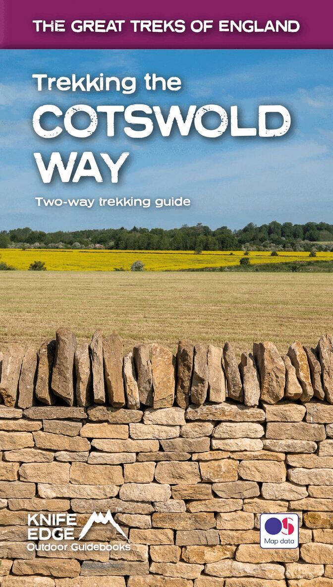
The definitive two-way guide to the Cotswold Way: both southbound and northbound routes are described in full. Real Maps: Full Ordnance Survey mapping inside (1:25,000). All accommodation is numbered and marked on the maps 18 different itineraries: schedules of 4, 5, 6, 7, 8, 9, 10, 11 and 12 days for hikers and runners. Includes both southbound and northbound itineraries. Difficult calculations of time, distance and altitude gain/loss are done for you. Also includes: Detailed information on equipment and travelling light Everything the trekker needs to know: route, costs, difficulty, weather, travel, and more Full accommodation listings: the best inns, B&Bs and hotels Detailed section on camping What to see in the City of Bath Essential info for both self-guided and guided trekkers Information on history, plants and wildlife Numbered waypoints linking the Real Maps to our clear descriptions The Cotswold Way travels 102 miles through the sublime scenery of the Cotswolds, a region which is the epitome of historic England. Along the way, you will travel the crest of the Cotswold Escarpment through exquisite rolling countryside and historic chocolate-box villages, built from lovely honey-coloured stone, which have remained unchanged for centuries. The trekker negotiates this wonderful terrain on a meticulously waymarked series of paths and tracks, far removed from the region?s large urban centres. Occasionally, you will pass through a small village or hamlet (with little more than a local pub and a few places to stay) but otherwise, the experience is one of tranquillity. This is England at its best and it will be an adventure that you will never forget.
Häftad, Engelska, 2022
331 kr
Skickas
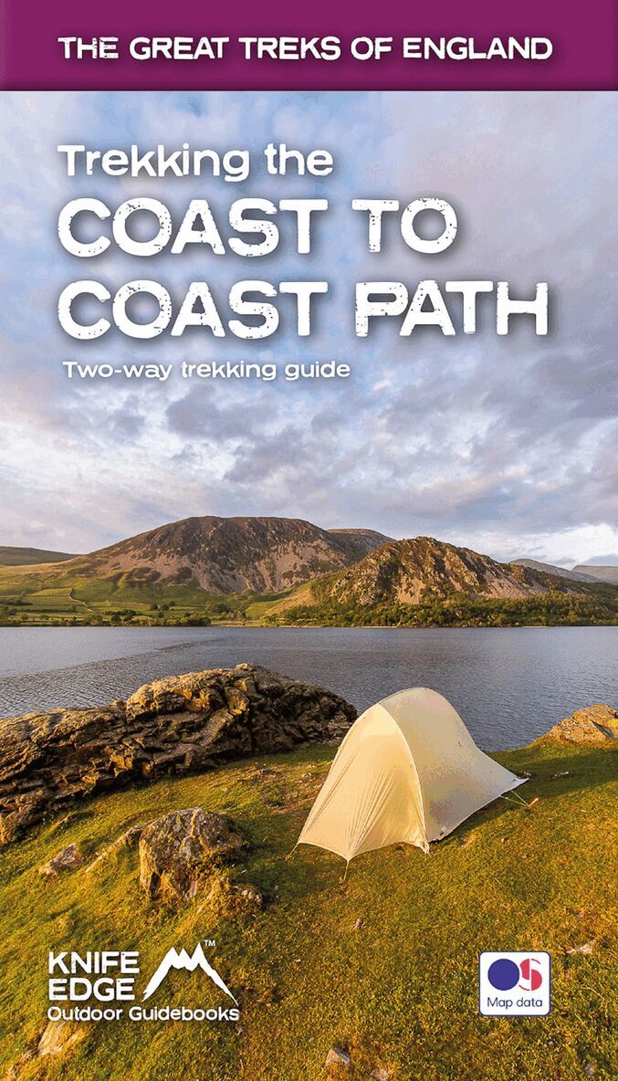
The definitive two-way guide to the Coast to Coast Path: both eastbound and westbound routes are described in full. Real Maps: Full Ordnance Survey mapping inside (1:25,000). All accommodation is numbered and marked on the maps. 19 different itineraries: schedules of 11, 12, 13, 14, 15, 16, 17, 18 and 19 days for hikers and runners. Includes both eastbound and westbound itineraries. Difficult calculations of time, distance and altitude gain/loss are done for you. Also includes: - Detailed information on equipment and travelling light - Full accommodation listings: the best pubs, B&Bs and hotels - Detailed section on camping, including wild camping - Everything the trekker needs to know: route, costs, difficulty, weather, travel, and more - Essential info for both self-guided and guided trekkers - Information on plants and wildlife - Numbered waypoints linking the Real Maps to our clear descriptions The Coast to Coast Path is the most popular and aspirational long-distance walking route in Britain. It was designed by Alfred Wainwright, the famous author of guidebooks to the Lake District. It travels across England from the Irish Sea to the North Sea. On the way, it traverses three stunning National Parks, each with its own unique scenery and character: the Lake District, the Yorkshire Dales and the North York Moors. This is England at its best and it will be an adventure that you will never forget.

Häftad, Engelska, 2023
222 kr
Skickas
The definitive two-way guide to the Cleveland Way, one of England's epic National Trails: both eastbound and westbound routes are described in full. Real Maps: Full Ordnance Survey mapping inside (1:25,000). All accommodation is numbered and marked on the maps. 20 different itineraries: schedules of 5, 6, 7, 8, 9, 10 and 11 days for hikers and runners. Includes both eastbound and westbound itineraries. Difficult calculations of time, distance and altitude gain/loss are done for you. Also includes: - Detailed information on equipment and travelling light - Full accommodation listings: the best pubs, B&Bs and hotels - Detailed section on camping, including wild camping - Everything the trekker needs to know: route, costs, difficulty, weather, travel, and more - Essential info for both self-guided and guided trekkers - Information on plants and wildlife - Numbered waypoints linking the Real Maps to our clear descriptions Yorkshire's Cleveland Way is one of the most beautiful long-distance walking routes in Britain. It is one of England's official 'National Trails'. The route circumnavigates the spectacular North York Moors National Park. It explores both the evocative expanses of Yorkshire's famous heather moorland and the never-ending cliffs of its coastline. This is England at its best and it will be an adventure that you will never forget.