
The Great Treks of the Alps – serie
Visar alla böcker i serien The Great Treks of the Alps. Handla med fri frakt och snabb leverans.
5 produkter
5 produkter

Häftad, Engelska, 2020
245 kr
Skickas
The only guidebook exclusively for the AV1. Everything you need to know to plan and walk Italy's most popular long-distance route. Real maps inside (Tabacco 1:25,000): the finest maps available for the Dolomites. This makes navigation easy and there is no need to carry additional maps. The AV1 is the premier route in the Dolomites. It is the perfect way to explore the range's exquisite beauty and its fascinating WW1 history. The AV1 is a linear route between Lago di Braies in the north and Belluno in the south. On the journey, you cross incredible high mountain passes enabling passage from magnificent valley to magnificent valley. And there are exquisite alpine plateaus, wonderful grassy pastures and carpets of wildflowers, the like of which you will never have seen before. You will live and breathe these scenic delights, night and day, because you need never leave the mountains. Unlike some alpine treks, the AV1 never enters villages or hamlets: fabulous accommodation is available in remote mountain huts cleverly spaced out along the route. Places with views that most people dream of but few will ever see. Places that you will never forget. Places that will leave you with remarkable memories. This is without a doubt a trek that should be on your bucket list. With the right preparation, planning and approach the AV1 is perfectly manageable for most people of reasonable fitness. Yes, it is a challenge, but it is an achievable one. And that is where this guide comes in! Most of what you need to know to prepare for the AV1 is here within these pages. And the entire route is described in detail to guide you on the trek itself. Furthermore, unlike other books, this one contains Real Maps: for each stage, there is a 1:25,000 scale map.

Häftad, Engelska, 2024
242 kr
Skickas
The definitive guidebook for the Tour des Combins: the new bucket list trek in the Swiss/Italian Alps. A superb alternative to the more famous Tour du Mont Blanc. Two-way guide: both clockwise and anti-clockwise routes are described in full. Real Maps: full mapping inside (1:40,000), made specifically for Knife Edge Outdoor Guidebooks. All accommodation/campsites are numbered and marked on the maps. 10 different itineraries: schedules of 6, 7, 8 and 9 days for hikers and runners. Includes both clockwise and anti-clockwise itineraries. Difficult calculations of time, distance and altitude gain/loss are done for you. Also includes: - Detailed information on equipment and travelling light - Full accommodation/campsite listings - Wild camping rules explained - Everything the trekker needs to know: route, costs, difficulty, weather and more - Travel to the trail-head - Essential info for both self-guided and guided trekkers - Information on plants and wildlife - Numbered waypoints linking the Real Maps to our clear descriptions The Tour des Combins is an epic trek in the Swiss and Italian Alps. It traverses some of Europe's wildest mountain terrain. The sublime scenery makes it a worthy alternative to the more famous Tour du Mont Blanc (which is only a stone's throw away). Hike along the edge of the Corbassiere Glacier, one of the longest in Europe. Enjoy snow frosted summits, magnificent valleys and pastures, sparkling azure lakes, carpets of wild flowers, the soothing sound of cow bells and easy to follow paths. Stay in spectacularly situated villages and remote mountain huts. This will be a trip that you will never forget.
225 kr
Skickas
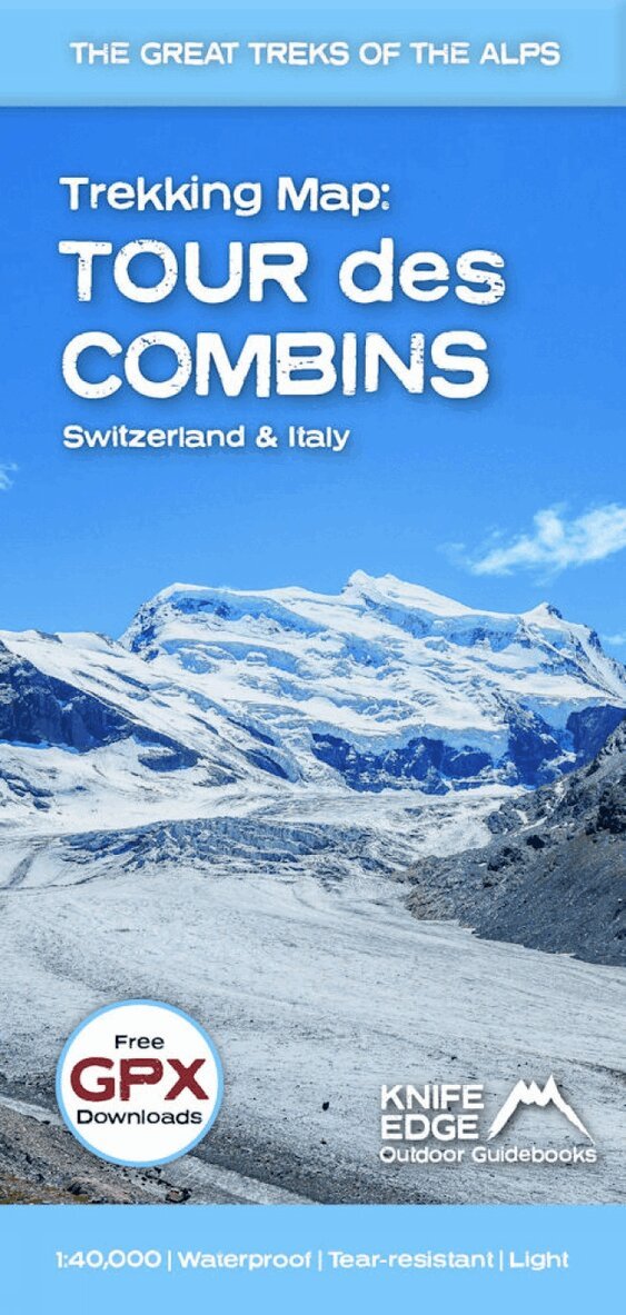
The best sheet map for the Tour des Combins. Displays the entire route and variants on a single sheet: perfect for planning and navigation. 1:40,000 - larger scale and more detail than any other map. Made specifically for the Tour des Combins by Knife Edge Outdoor Guidebooks: - English/French/German map key - 1:40,000 - Numerous variants - Includes free GPX downloads for the trail - GPS compatible - Tougher than traditional maps: try to tear it! - More water-resistant than traditional maps - Lighter than traditional maps - Huts/accommodation marked on the map The Tour des Combins is an epic trek in the Swiss and Italian Alps. It traverses some of Europe's wildest mountain terrain. The sublime scenery makes it a worthy alternative to the more famous Tour du Mont Blanc (which is only a stone's throw away). Hike along the edge of the Corbassiere Glacier, one of the longest in Europe. Enjoy snow frosted summits, magnificent valleys and pastures, sparkling azure lakes, carpets of wild flowers, the soothing sound of cow bells and easy to follow paths. Stay in spectacularly situated villages and remote mountain huts. This will be a trip that you will never forget.
Engelska, 2024
225 kr
Skickas
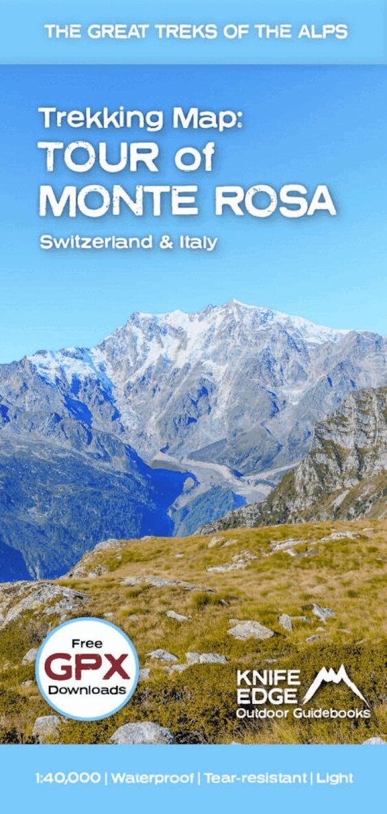
The best sheet map for the Tour of Monte Rosa. This is the only map available that displays the entire route and variants on a single sheet: perfect for planning and navigation. 1:40,000 - larger scale and more detail than any other map. Made specifically for the Tour of Monte Rosa by Knife Edge Outdoor Guidebooks: - English/French/German map key - 1:40,000 - Numerous variants - Includes free GPX downloads for the trail - GPS compatible - Tougher than traditional maps: try to tear me! - More water-resistant than traditional maps - Lighter than traditional maps - Huts/accommodation marked on the map The Tour of Monte Rosa is an incredible trek in the Swiss and Italian Alps. It circumnavigates the Monte Rosa Massif, passing Zermatt and Saas Fee (two of the most famous Alpine towns). On the way, pass the largest collection of snowy 4000m summits in the Alps: Mont Blanc, Grand Combin, the Weisshorn, the Zinalrothorn, the Dom, the Taschhorn, the Breithorn and the Matterhorn, to name a few. The sister trek to the Walker's Haute Route crosses unspoilt and remote mountain terrain: amazing glaciers, snow frosted summits, beautiful valleys and pastures, shimmering lakes, carpets of wild flowers and the soothing sound of cow bells. This trek should be on your hiking bucket list.
Häftad, Engelska, 2024
247 kr
Skickas
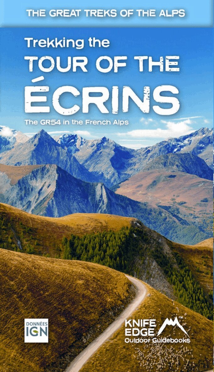
The only English language guidebook for the GR54 has been completely rewritten and fully updated for 2024. Real 1:25,000 Maps: IGN mapping included for each stage. This makes navigation easy and saves you money: no need to buy additional maps. Also includes: -Unique Itinerary Planner: plan a bespoke itinerary to match your ability and vacation schedule. All difficult calculations of time, distance and altitude gain are done for you -4 Proposed Itineraries of between 9 and 12 days -Detailed information on equipment and travelling light -Everything the trekker needs to know to plan the route: route descriptions, costs, budget, difficulty, weather, how to get there, and more -Full accommodation listings: spectacularly situated mountain huts, villages, hamlets and campsites -Essential travel information -Information for both self-guided and guided trekkers -Numbered waypoints linking the Real Maps to our clear descriptions The GR54: Tour of the Ecrins National Park is arguably the finest trek in the Alps. It is an epic journey around the unforgettable Ecrins which has the highest mountains in the French Alps outside of the Mont Blanc Massif. This is one of France's 'crown jewels' and yet is hardly known to the English-speaking world. -193km -9-12 days -12,000m of altitude gain -14 mountain passes Unspoilt and remote high mountain terrain: snow frosted summits, beautiful valleys and pastures, sparkling azure lakes, carpets of wild flowers, the soothing sound of cow bells and easy to follow paths. This trek should be on your hiking bucket list.