
Jan Kostura – författare
Visar alla böcker från författaren . Handla med fri frakt och snabb leverans.
10 produkter
10 produkter
Engelska, 2020
67 kr
Skickas inom 11-20 vardagar
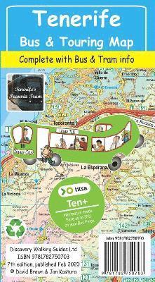
Tenerife Bus & Touring Map, the island's most popular map, is now back in its new 7th edition for 2020 now that TITSA (island bus company) has finished reorganising its routes and bus stations, and the island authorities have completed their road numbering system; extended motorway system and junctions numbered by their kilometer marker. Tenerife island map at 1:100k scale along with updated large scale street plans for Las America/Los Cristianos, Santa Cruz, Puerto de la Cruz, Los Gigantes/Puerto Santiago/Playa la Arena, Golf del Sur/Amarilla Golf, Las Galletas/Costa del Silencio. Masses of Titsa bus routes and timetable information including the Ten+ discount bus tickets used on Titsa buses; saving up to 50% on the already pocket-money fares. Tenerife island map has been drawn with particular emphasis on navigation by road and Titsa bus routes. Extensive place name index makes finding your destination on the island quick and easy, while our bus terminus and bus route numbering helps you find the routes you need to go where you want to go. Tenerife Bus & Touring Map is your best choice for exploring the stunning landscapes of the Island of Eternal Spring and is the travel essential for everyone visiting this exciting island in the Canaries. 860mm by 660mm makes Tenerife Bus & Touring Map a big map but thanks to our specialist 'concertina map fold' it is easy to open, and more importantly easy to refold to its convenient pocket size.
Häftad, Engelska, 2018
165 kr
Skickas
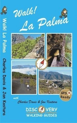
Revised and updated 4th edition of Walk! La Palma including the latest Tour & Trail Mapping. Walk! La Palma includes 37 fully detailed walking route itineraries. Each walking route itinerary includes:- - walking route summary - ratings for Effort, Time, Distance, Ascents/Descents, Refreshments and Vertigo risk - fully detailed walk description, including frequent timings to aid navigation and check your progress - GPS Waypoints at every key point on every route where there is good gps reception - full colour 1:40,000 scale map of the route - short walk and stroll alternatives There are some easy routes. There are some challenging routes for fit experts. With author/researchers Charles Davis' and Jan Kostura's excellent walk descriptions you'll know which routes are for you - and all of them are a true adventure. The steepest island in the world, the deepest crater, the clearest skies: volcanoes you can climb without being shot into orbit; a subtropical forest minus the slimy things slinking up your trouser leg; black beaches, blue seas, high mountains, vegetation that is literally flamboyant, everything linked by 1080 kilometres of waymarked paths; and all virtually untouched by tourism. If this sounds divine or like some lost paradise, you're not the first to think so, previous commentators have identified La Palma as the prototype for both the Elysian Fields and Atlantis! The fanciful stuff aside, the island is a walker's idyll, utterly tranquil, verdant and almost unspoiled. GPS Waypoint files (in gpx file format) for Walk! La Palma are available as a free zip file download on Discovery Walking Guides website. Synopsis 37 detailed walking route itineraries. Each route includes:- walking route summary; ratings for Effort, Time, Distance, Ascents/Descents, Refreshments and Vertigo risk; and more. It also provides background information along with details of accommodation, buses, official walking routes, mountain biking, museums, and information offices.
Engelska, 2019
151 kr
Skickas
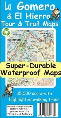
Quite simply La Gomera and El Hierro Tour & Trail Maps are the most detailed, accurate, toughest, easy to read, large scale maps of La Gomera and El Hierro that you can buy. Our map sheet is 840mm by 680mm. On the cover side you get the latest 35k scale 8th edition La Gomera Tour & Trail Map by David Brawn. On the reverse side is our 35k scale 1st edition El Hierro Tour & Trail Map by Jan Kostura. Both maps are produced to our 'Tour & Trail' level of detail ranging from major roads to secondary roads to minor roads to streets and camino rural narrow country roads, plus dirt roads and walking trails. Walking trails are specially highlighted, GR (Gran Recorido trails in green) and Walk La Gomera (in red), making them easier to identify on the maps and easier to find on the ground. Altitude background colouring is designed to clearly show the altitude range when traveling across each island by car or on foot. 100 metre and 50 metre contours, 100m and 20m on El Hierro, are clearly shown on the map along with a large number of individual height points and all of the official 'Trig' points. Tour & Trail attention to detail is legendary as is our useful symbol range including miradors, picnic areas, petrol stations, bar/restaurants and parking areas where you can pull off the road safely.You will easily identify springs, caves, sports grounds, cemeterys, churchs, chapels, lighthouses, towers and forts, camping areas, wind turbines, hotels and those all important information offices. For adventurers on foot Tour & Trail Maps are researched and designed by hikers for use by hikers. Our comprehensive gps ground surveys produce the best road mapping available but the value of this on the ground research becomes even more important when you leave the tarmac. Digital editions of these maps are available on the dwgwalking website. These Super-Durable Maps are printed using UV cured inks printed onto a 100 micron plastic substrate. This produces a Super-Durable map sheet that feels like silk but will stand up to the roughest treatment of outdoor adventuring and yet fold up like new at the end of your adventure. DWG's special concertina map fold means your map is easy to unfold, and easy to fold back to its folded pocket size. Super-Durable Maps come with a 2 year adventurous use wear and tear guarantee. For your best adventures, choose the best map.
Engelska, 2019
151 kr
Skickas
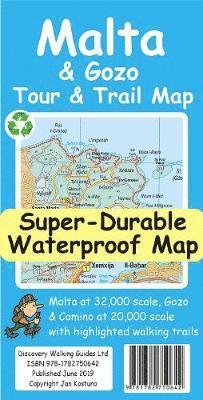
For the best adventures, use the best map. Water-proof, split-proof, tear-proof, adventure-proof. Malta and Gozo Tour & Trail Super-Durable Map is simply the toughest, most accurate, easy to read, easy to use map of the island you can buy at any price. Super-Durable Maps come with a 2 year adventurous use `Wear and Tear' guarantee. A large 840mm by 694mm double sided map sheet has Malta at 1:32,000 scale on one side, with Gozo at 1:20,000 scale on the reverse. Our special concertina map fold makes our map easy to use and easy to refold to its 235mm by 120mm pocket size. Our legendary 'Tour & Trail' level of detail ranges from major roads to secondary roads to minor roads to streets and narrow country roads, plus dirt roads and walking trails. Altitude background colouring is designed to clearly show the altitude range when travelling across the islands by car or on foot. 100 metre and 20 metre contours are clearly shown on the map along with individual height points and all of the official 'Trig' points. Tour & Trail attention to detail includes our useful symbol range including viewpoints, picnic areas, petrol stations, bar/restaurants and parking areas where you can pull off the road safely. You will easily identify springs, caves, sports grounds, cemeteries, churches, chapels, lighthouses, towers and forts, camping areas, wind turbines, hotels etc. We have ensured that all the walking routes from the Sunflower and Rother walking guide books are highlighted (red) on the maps. It all adds up to the most detailed, most durable, most useful maps of Malta and Gozo that you can buy anywhere. 'Super-Durable' means a waterproof, tear-proof, map that can take the roughest treatment and still folds up like new after your adventures. Our special concertina map fold means this 'near indestructible' Tour & Trail Map unfolds easily for use, and more importantly folds back up easily to its compact pocket size even after the toughest use. Digital editions of our Malta and Gozo Tour & Trail Map are available for phone apps and Garmin users on our Discovery Walking Guides website.
Engelska, 2019
151 kr
Skickas
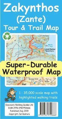
For the best adventures, use the best map. Water-proof, split-proof, tear-proof, adventure-proof. Zakynthos (Zante) Tour & Trail Super-Durable Map is simply the toughest, most accurate, easy to read, easy to use map of the island you can buy at any price. Super-Durable Maps come with a 2 year adventurous use `Wear and Tear' guarantee. A large 840mm by 694mm double sided map sheet has Zakynthos (Zante) at 1:35,000 scale with the North-West of the island on the cover side and the South-East on the reverse. There is a very generous overlap between the two sides so the only time you need to turn the map over is if you are driving from Cape Skinari (NW) to Cape Gerakas (SE) at the opposite end of the island. Our special concertina map fold makes our map easy to use and easy to refold to its 235mm by 120mm pocket size. You can also download the digital Custom Map edition of our Zakynthos Tour & Trail Map for use with Garmin gps units and software; simply follow the instructions on the map sheet. Our legendary 'Tour & Trail' level of detail ranges from major roads to secondary roads to minor roads to streets and narrow country roads, plus dirt roads and walking trails. Place names are in English and Greek to aid your navigation. Altitude shading is designed to clearly show the altitude range when travelling across the island by car or on foot. 100 metre and 20 metre contours are clearly shown on the map along with individual height points and all of the official 'Trig' points. Tour & Trail attention to detail includes our useful symbol range including viewpoints, picnic areas, petrol stations, bar/restaurants and parking areas where you can pull off the road safely. You will easily identify springs, caves, sports grounds, cemeteries, churches, chapels, lighthouses, towers and forts, camping areas, wind turbines, hotels etc. We have ensured that all the walking routes from the Sunflower walking guide book are highlighted (red) on the maps. It all adds up to the most detailed, most durable, most useful map of Zakynthos (Zante) that you can buy anywhere. Digital editions are available for phone apps and Garmin users from the Discovery Walking Guides website.
Häftad, Engelska, 2020
163 kr
Skickas
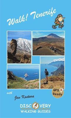
TENERIFE - A WALKER'S ISLAND Tenerife is a big island - 2034 square kilometres big. It offers walkers a wide variety of exciting landscapes to choose from; everything from coastal strolls, high altitude summits, pine forests and laurel forests, challenging and strenuous routes to easy country walks. Walk! Tenerife is a comprehensive walking guide book to Tenerife's best walking. 42 fully detailed walking routes with large scale maps. GPS Waypoints for all 42 routes can be downloaded for free from Discovery Walking Guides website. In the North choose from walks through pine forests and along forest tracks and walking trails, with fine views in clear weather. The South has diverse routes; forest walks, mountains and barrancos, villages and untouched wild countryside. The West offers mountain routes and rugged country hikes. The Central High Altitude region is home to some of the most exciting mountain and canadas routes within the National Park, including the Paisaje Lunar route, and the challenges of `The Big One - Crater Rim Challenge' and the ascent of Mount Teide. The rugged Anaga in the far north-east offers wild beauty, tiny hamlets, soaring peaks and plunging barrancos. Routes vary in approximate walking time from 90 minutes to over 6 hours, and from 5 to 18 kilometres in length. Ascents and descents are shown for each walk. Difficulty ratings from 2 to 5 walker help you choose the right route. Refreshment ratings are shown and vertigo risk is shown where appropriate. Some routes are circular, others linear `out-and-back' or linear one way. Access to routes by bus and/or by car ensure you reach the start and get back from the end safely. Enjoy the rich variety of landscapes and adventures that Tenerife has to offer.
Häftad, Engelska, 2022
163 kr
Skickas
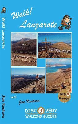
Lanzarote's most popular walking guide book just got even better. Walk! Lanzarote 5th edition builds on the reputation of our earlier editions with comprehensive updating so that it caters for the needs of the increasing number of people who would like to combine some walking with a holiday on the Fire island. Walk Lanzarote explodes the myth that there is nowhere worth walking on the island as we range through strolling on coastal promenades, walking across alpine style meadows, striding over the lava sea, dropping into volcanoes, sitting on high mountain seats - quite simply you will be amazed at the wide variety of stunning landscapes the Fire island has to offer the adventurous leisure walker. For the 5th edition we've checked several routes and updated them where necessary. Walk Lanzarote's forty one main walking routes provide a wide variety of adventures with routes ranging from family friendly costal promenades through a surprising range of landscapes up to some serious hiking. Every route is an adventure that will make you eager to explore further on this spectacular island. Walk Lanzarote is produced to our highest standards with walk summary and rating, fully detailed description, frequent timings so you can check your progress, compass directions, and gps waypoints for all country routes. Each country route has full 1:40,000 scale colour mapping and gps waypoints dedicated to that route, while our Teguise town walk uses a large scale street plan. All routes are illustrated with colour photos. Culture and agriculture are included along with a Thingy section on modern art. We've emphasised the Access by Bus sections for each walk along with our Access by Car information for each walking route. Map sections for each route are taken from the Lanzarote Tour & Trail Super-Durable Map 5th edition. For gps users the gps waypoint files are available as a free downloadable zip file on the Discovery Walking Guides website. Quite simply the best book of Lanzarote that you can buy. If this is your first visit to Lanzarote then Walk! Lanzarote plus Lanzarote Tour & Trail Map will give you a series of adventures that will have you returning to the Fire island to experience more.
Engelska, 2020
151 kr
Skickas
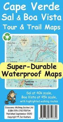
For your best adventures, use the best maps. Water-proof, split-proof, tear-proof, adventure-proof. Sal and Boa Vista Tour & Trail Super-Durable Maps are simply the toughest, most accurate, easy to read, easy to use maps of these two islands that you can buy at any price. A large 840mm by 690mm double sided map sheet has Sal at 1:40,000 scale on the cover side, with Boa Vista at 1:45,000 scale on the reverse. There are also street plans of Espargos, Santa Maria (Sal) and Sal Rei (Boa Vista) at 1:10,000 scale. Our special concertina map fold makes our map easy to open and easy to refold to its 230mm by 120mm pocket size. Our legendary 'Tour & Trail' level of detail ranges from major roads to secondary roads to minor roads to streets and narrow country roads, plus dirt roads, tracks and walking trails. Altitude shading each 100 metres is designed to clearly show the altitude range when travelling across the island by car or on foot. 20 metre and 100 metre contours combined with altitude shading bring these beautiful landscapes to life. There are plenty of individual height points and all of the official 'Trig' points are on the maps. Tour & Trail attention to detail includes our useful symbol range including viewpoints, petrol stations, bar/restaurants and parking areas where you can pull off the road safely. You will easily identify springs, caves, sports grounds, cemeteries, churches, chapels, lighthouses, corrals, wind turbines, hotels, sand dunes etc. Published walking routes are highlighted on the maps. It all adds up to the most detailed and most durable maps of Sal and Boa Vista that you can buy anywhere. 'Super-Durable' means a waterproof, tear-proof, map that can take the roughest treatment and still folds up like new after your adventures. Super-Durable Maps come with a 2 year adventurous use 'Wear and Tear' guarantee. Digital editions of our Sal and Boa Vista Tour and Trail Maps are available for phone apps and Garmin users on our Discovery Walking Guides website.
Häftad, Engelska, 2023
149 kr
Skickas
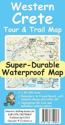
For your best adventures, use the best map. Water-proof, split-proof, tear-proof. Western Crete Tour & Trail Super-Durable Map is simply the toughest, most accurate, easy to read, easy to use map that you can buy at any price. A large 960mm by 694mm double sided map sheet at 1:40,000 scale covers area of over 1600km2, from Paleochora in the west to Preveli beach in the east. The map covers the most important hiking regions in the western Crete, including the famous Samaria Gorge, Lefka Ori (White Mountains) and much more. Our legendary 'Tour & Trail' level of detail ranges from major roads to secondary roads to minor roads to streets and narrow country roads, plus dirt roads, tracks and walking trails. Place names are in English and Greek to aid your navigation. Altitude shading is designed to clearly show the altitude range when travelling across the island by car or on foot. 20-metre and 100-metre contours combined with altitude shading bring this beautiful landscape to life. There are plenty of individual height points and all of the official 'Trig' points are on the map. Tour & Trail attention to detail includes our useful symbol range including viewpoints, picnic areas, petrol stations, bar/restaurants and parking areas where you can pull off the road safely. You will easily identify springs, caves, sports grounds, cemeteries, monasteries, churches, chapels, lighthouses, forts, camping areas, waterfalls, wind turbines, windmills, hotels etc. For walkers, the E4 long distance walking route is specially highlighted on the map in red. Published walking routes are highlighted in green. It all adds up to the most detailed, most durable map of Western Crete that you can buy anywhere. 'Super-Durable' means a waterproof, tear-proof, map that can take the roughest treatment and still folds up like new after your adventures. Super-Durable Maps come with a 2-year adventurous use 'Wear and Tear' guarantee. DWG's special concertina map fold makes our map easy to open and easy to refold back to its 232mm by 120mm size. Digital editions of our Western Crete Tour & Trail Map are available as in-app purchases for Outdooractive, Locus Map and Avenza apps
Häftad, Engelska, 2024
146 kr
Skickas
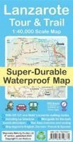
Water-proof, split-proof, tear-proof, adventure-proof. Lanzarote Tour & Trail Super-Durable Map is simply the toughest, most accurate, easy to read, easy to use multipurpose map that you can get. A large 960mm by 694mm double sided map sheet covers Lanzarote and its neighbouring island La Graciosa at 1:40,000 scale.