
Qihao Weng – författare
1 814 kr
Skickas inom 3-6 vardagar
Publisher's Note: Products purchased from Third Party sellers are not guaranteed by the publisher for quality, authenticity, or access to any online entitlements included with the product.
Maximize a geographical information tool by incorporating it with up-to-date remotely sensed data
GIS is predominantly a data-handling technology, while remote sensing is a data retrieval and analysis technology. This book addresses the need to combine remotely sensed data with cartographic, socioeconomic, and environmental data and GIS functionalities.
Remote Sensing and GIS Integration begins with theoretical discussions, followed by a series of application areas in urban and environmental studies that employ the integration of remote sensing and GIS. Each application area is examined through analysis of state-of-the-art methods and detailed presentations of one or more case studies.
2 320 kr
Läs direkt efter köp
Publisher''s Note: Products purchased from Third Party sellers are not guaranteed by the publisher for quality, authenticity, or access to any online entitlements included with the product.
Maximize a geographical information tool by incorporating it with up-to-date remotely sensed data
GIS is predominantly a data-handling technology, while remote sensing is a data retrieval and analysis technology. This book addresses the need to combine remotely sensed data with cartographic, socioeconomic, and environmental data and GIS functionalities.
Remote Sensing and GIS Integration begins with theoretical discussions, followed by a series of application areas in urban and environmental studies that employ the integration of remote sensing and GIS. Each application area is examined through analysis of state-of-the-art methods and detailed presentations of one or more case studies.
1 340 kr
Skickas inom 3-6 vardagar
Publisher's Note: Products purchased from Third Party sellers are not guaranteed by the publisher for quality, authenticity, or access to any online entitlements included with the product.
A PRACTICAL, FULL-COLOR GUIDE TO REMOTE SENSING
Written by an internationally renowned expert in the field, An Introduction to Contemporary Remote Sensing introduces the latest developments in remote sensing and imaging science. This book covers basic principles and discusses essential technologies, such as aerial photography, radar, Lidar (light detection and ranging), photogrammetry, satellites, thermal radiation, and much more. Full-color images illustrate the concepts presented, and review questions at the end of each chapter help reinforce learning. This detailed resource provides the solid foundation in remote sensing required for developing diverse geospatial applications.
Coverage includes:
Geographic information system (GIS)Global positioning system (GPS), mobile mapping, and Google EarthElectromagnetic radiation principlesCharacteristics of remotely sensed dataSpatial, spectral, radiometric, and temporal resolutionAerial photo interpretationPhotogrammetryRemote sensorsEarth observation satellitesDigital image analysisThermal remote sensingActive remote sensing
1 594 kr
Läs direkt efter köp
A PRACTICAL, FULL-COLOR GUIDE TO REMOTE SENSING
Written by an internationally renowned expert in the field, An Introduction to Contemporary Remote Sensing introduces the latest developments in remote sensing and imaging science. This book covers basic principles and discusses essential technologies, such as aerial photography, radar, Lidar (light detection and ranging), photogrammetry, satellites, thermal radiation, and much more. Full-color images illustrate the concepts presented, and review questions at the end of each chapter help reinforce learning. This detailed resource provides the solid foundation in remote sensing required for developing diverse geospatial applications.
Coverage includes:
Geographic information system (GIS)Global positioning system (GPS), mobile mapping, and Google EarthElectromagnetic radiation principlesCharacteristics of remotely sensed dataSpatial, spectral, radiometric, and temporal resolutionAerial photo interpretationPhotogrammetryRemote sensorsEarth observation satellitesDigital image analysisThermal remote sensingActive remote sensing
783 kr
Skickas inom 10-15 vardagar
783 kr
Skickas inom 10-15 vardagar
741 kr
Skickas inom 10-15 vardagar
1 037 kr
Skickas inom 10-15 vardagar
1 037 kr
Skickas inom 10-15 vardagar
840 kr
Skickas inom 10-15 vardagar
1 405 kr
Skickas inom 10-15 vardagar

925 kr
Läs direkt efter köp
Urban Remote Sensing, Second Edition assembles a team of professional experts to provide a much-needed update on the applications of remote sensing technology to urban and suburban areas. This book reflects new developments in spaceborne and airborne sensors, image processing methods and techniques, and wider applications of urban remote sensing to meet societal and economic challenges. In various sections of the book the authors address methods for upscaling urban feature extraction to the global scale, new methods in mapping and detecting urban landscape features and structures, and mapping and monitoring urbanization in developing countries. Additionally, readers are provided with valuable case studies such as the HEAT (Heat Energy Assessment Technologies) project in Calgary, Canada and the use of VHR (very high resolution) satellite monitoring in Salzburg, Austria to tackle challenges of urban green planning.
Features
Explores the most up-to-date developments in the field of urban remote sensingIntegrates both technical and practical aspects covering all different topics of global urban growth issues
Provides new and updated contributions addressing data mining of remotely sensed big data, recent urban studies on a global scale, accuracy assessment and validation, and new technical challenges
Examines various applications of urban remote sensing in support of urban planning, environmental management, and sustainable urban development
Authors are renowned figures in the field of remote sensing
3 951 kr
Läs direkt efter köp
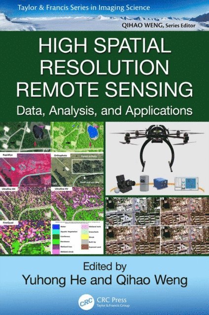
High spatial resolution remote sensing is an area of considerable current interest and builds on developments in object-based image analysis, commercial high-resolution satellite sensors, and UAVs. It captures more details through high and very high resolution images (10 to 100 cm/pixel). This unprecedented level of detail offers the potential extraction of a range of multi-resource management information, such as precision farming, invasive and endangered vegetative species delineation, forest gap sizes and distribution, locations of highly valued habitats, or sub-canopy topographic information. Information extracted in high spatial remote sensing data right after a devastating earthquake can help assess the damage to roads and buildings and aid in emergency planning for contact and evacuation.
To effectively utilize information contained in high spatial resolution imagery, High Spatial Resolution Remote Sensing: Data, Analysis, and Applications addresses some key questions:
What are the challenges of using new sensors and new platforms?
What are the cutting-edge methods for fine-level information extraction from high spatial resolution images?
How can high spatial resolution data improve the quantification and characterization of physical-environmental or human patterns and processes?
The answers are built in three separate parts: (1) data acquisition and preprocessing, (2) algorithms and techniques, and (3) case studies and applications. They discuss the opportunities and challenges of using new sensors and platforms and high spatial resolution remote sensing data and recent developments with a focus on UAVs. This work addresses the issues related to high spatial image processing and introduces cutting-edge methods, summarizes state-of-the-art high spatial resolution applications, and demonstrates how high spatial resolution remote sensing can support the extraction of detailed information needed in different systems. Using various high spatial resolution data, the third part of this book covers a range of unique applications, from grasslands to wetlands, karst areas, and cherry orchard trees.

3 812 kr
Läs direkt efter köp
High spatial resolution remote sensing is an area of considerable current interest and builds on developments in object-based image analysis, commercial high-resolution satellite sensors, and UAVs. It captures more details through high and very high resolution images (10 to 100 cm/pixel). This unprecedented level of detail offers the potential extraction of a range of multi-resource management information, such as precision farming, invasive and endangered vegetative species delineation, forest gap sizes and distribution, locations of highly valued habitats, or sub-canopy topographic information. Information extracted in high spatial remote sensing data right after a devastating earthquake can help assess the damage to roads and buildings and aid in emergency planning for contact and evacuation.
To effectively utilize information contained in high spatial resolution imagery, High Spatial Resolution Remote Sensing: Data, Analysis, and Applications addresses some key questions:
What are the challenges of using new sensors and new platforms?
What are the cutting-edge methods for fine-level information extraction from high spatial resolution images?
How can high spatial resolution data improve the quantification and characterization of physical-environmental or human patterns and processes?
The answers are built in three separate parts: (1) data acquisition and preprocessing, (2) algorithms and techniques, and (3) case studies and applications. They discuss the opportunities and challenges of using new sensors and platforms and high spatial resolution remote sensing data and recent developments with a focus on UAVs. This work addresses the issues related to high spatial image processing and introduces cutting-edge methods, summarizes state-of-the-art high spatial resolution applications, and demonstrates how high spatial resolution remote sensing can support the extraction of detailed information needed in different systems. Using various high spatial resolution data, the third part of this book covers a range of unique applications, from grasslands to wetlands, karst areas, and cherry orchard trees.
2 661 kr
Skickas inom 10-15 vardagar

896 kr
Skickas inom 10-15 vardagar

2 942 kr
Läs direkt efter köp
2 942 kr
Läs direkt efter köp
1 227 kr
Läs direkt efter köp
1 227 kr
Läs direkt efter köp
844 kr
Läs direkt efter köp
Remote sensing of impervious surfaces has matured using advances in geospatial technology so recent that its applications have received only sporadic coverage in remote sensing literature. Remote Sensing of Impervious Surfaces is the first to focus entirely on this developing field. It provides detailed coverage of mapping, data extraction,
1 580 kr
Läs direkt efter köp
992 kr
Läs direkt efter köp
1 534 kr
Skickas inom 5-8 vardagar
1 658 kr
Skickas inom 5-8 vardagar

1 898 kr
Läs direkt efter köp
Provides up-to-date developments in the field of remote sensing by assessing scale issues in land surface, properties, patterns, and processes
Scale is a fundamental and crucial issue in remote sensing studies and image analysis. GIS and remote sensing scientists use various scaling techniques depending on the types of remotely sensed images and geospatial data used. Scaling techniques affect image analysis such as object identification and change detection.
This book offers up-to-date developments, methods, and techniques in the field of GIS and remote sensing and features articles from internationally renowned authorities on three interrelated perspectives of scaling issues: scale in land surface properties, land surface patterns, and land surface processes. It also visits and reexamines the fundamental theories of scale and scaling by well-known experts who have done substantial research on the topics.
Edited by a prominent authority in the geographic information science community, Scale Issues in Remote Sensing:
Offers an extensive examination of the fundamental theories of scale issues along with current scaling techniques Studies scale issues from three interrelated perspectives: land surface properties, patterns, and processes Addresses the impact of new frontiers in Earth observation technology (high-resolution, hyperspectral, Lidar sensing, and their synergy with existing technologies) and advances in remote sensing imaging science (object-oriented image analysis and data fusion) Prospects emerging and future trends in remote sensing and their relationship with scaleScale Issues in Remote Sensing is ideal as a professional reference for practicing geographic information scientists and remote sensing engineers as well as supplemental reading for graduate level students.
1 756 kr
Läs direkt efter köp
An authoritative guide to the essential techniques and most recent advances in urban remote sensing
Techniques and Methods in Urban Remote Sensing offers a comprehensive guide to the recent theories, methods, techniques, and applications in urban remote sensing. Written by a noted expert on the subject, this book explores the requirements for mapping impervious surfaces and examines the issue of scale. The book covers a range of topics and includes illustrative examples of commonly used methods for estimating and mapping urban impervious surfaces, explains how to determine urban thermal landscape and surface energy balance, and offers information on impacts of urbanization on land surface temperature, water quality, and environmental health.
Techniques and Methods in Urban Remote Sensing brings together in one volume the latest opportunities for combining ever-increasing computational power, more plentiful and capable data, and more advanced algorithms. This allows the technologies of remote sensing and GIS to become mature and to gain wider and better applications in environments, ecosystems, resources, geosciences, geography and urban studies. This important book:
Contains a comprehensive resource to the latest developments in urban remote sensing Explains urban heat islands modeling and analysis Includes information on estimating urban surface energy fluxes Offers a guide to generating data on land surface temperatureWritten for professionals and students of environmental, ecological, civic and urban studies, Techniques and Methods in Urban Remote Sensing meets the demand for an updated resource that addresses the recent advances urban remote sensing.