123 kr
Skickas . Fri frakt över 249 kr.
Beskrivning
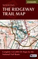
Stretching 87 miles (139km) across southern England, the Ridgeway National Trail runs from Avebury in Wiltshire to Ivinghoe Beacon in Buckinghamshire along one of Britain’s oldest roads. This low-level, accessible long-distance trail typically takes 6–9 days and passes through the North Wessex Downs and Chiltern Hills, offering sweeping views and a journey through thousands of years of history. The Ridgeway Map Booklet is a compact, lightweight walking map and navigation companion featuring the entire route on detailed Ordnance Survey 1:25,000 mapping. Designed for use on the move, it provides clear, reliable navigation in a convenient pocket-sized format. Full Ridgeway National Trail route shown on Ordnance Survey 1:25,000 mapping for precise navigation from Avebury to Ivinghoe BeaconClearly marked trail line across the North Wessex Downs and Chiltern Hills, including detours to historic and archaeological sites along the routeContinuous mapping across the entire route in a compact booklet, eliminating the need for multiple separate map sheetsLightweight, pocket-sized trail map that can be used to walk the trail in either directionFor step-by-step route descriptions and planning advice, a Cicerone guidebook, Walking the Ridgeway, is also available Whether you’re following ancient trackways past prehistoric monuments or enjoying wide-open chalk downland, the Ridgeway Map Booklet keeps navigation simple and stress-free, helping you focus on the history, landscapes and experience of this iconic National Trail.