
-Z Adventure Series – serie
Visar alla böcker i serien -Z Adventure Series. Handla med fri frakt och snabb leverans.
17 produkter
17 produkter
Häftad, Engelska, 2025
153 kr
Skickas
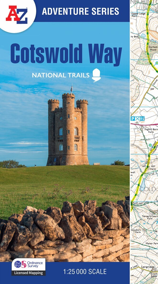
The A-Z Adventure Series uses Ordnance Survey mapping and is the perfect companion for walkers, off-road cyclists, and anyone wishing to explore the great outdoors.The Cotswold Way is a 102 mile (164 km) National Trail running along the Cotswold Hills. Starting in the historic City of Bath and finishing in Chipping Campden, the clearly marked route passes through numerous places of interest and an abundance of wildlife.This official National Trail Map features detailed Ordnance Survey mapping at a scale of 1:25 000, providing complete coverage of the Cotswold Way. There is also a route planner included to show distances between places and the amenities available making it easy to plan your adventure. Additional features include: Information CentresHotels/B&BsYouth HostelsCampsites (seasonal opening)Public HousesRestaurantsShopsCafes (seasonal opening)Petrol StationsOther books available in the A-Z Adventure series include: Peak District (Dark Peak), Peddars Way and Norfolk Coast Path, South Downs Way, Pembrokeshire Coast Path, South West Coast Path and The North Coast 500.
Häftad, Engelska, 2024
127 kr
Skickas
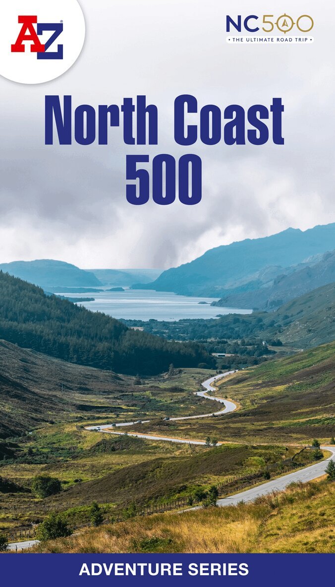
The A-Z Adventure Series of maps is the perfect companion for walkers, off-road cyclists, and anyone wishing to explore the great outdoors.The scenic North Coast 500 is one of the most popular routes in Scotland and journeying along it makes for an incredible adventure. The 516 mile (830 km) route passes through picturesque landscapes and abundant wildlife, linking a wide range of tourist destinations in the Highlands.This A-Z North Coast 500 Adventure Atlas features more than 90 pages of continuous 1:50 000 mapping, providing detailed coverage of the entire route. A route planner showing distances between places and the amenities available is also included, along with the locations of: Campsites (seasonal opening)Information CentresHotels/B&BsYouth HostelsPubs, Restaurants and CafesShopsPetrol StationsNow with NEW electric charge point data from Zapmap!Other walks available in the A-Z Adventure series include: Cotswold Way, Peddars Way and Norfolk Coast Path, Coast to Coast Path, South Downs Way and The Pembrokeshire Coast Path.
Häftad, Engelska, 2025
151 kr
Skickas
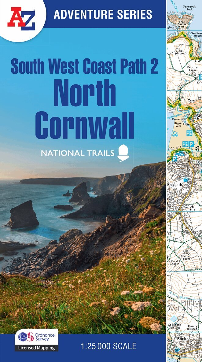
Plan your next adventure along the North Cornwall section of the South West Coast Path with trusted mapping from A-ZThe perfect companion for those wanting to explore the iconic route as seen in The Salt Path, the A-Z Adventure Series features 1:25 000 Ordnance Survey mapping in a convenient book, complete with index.The South West Coast Path is a National Trail along the Somerset, Devon, Cornwall and Dorset coasts. This stunning walk from Minehead, Somerset covers 630 miles to South Haven Point in Poole Harbour, passing through two World Heritage Sites (the Jurassic Coast and the Cornwall and West Devon Mining Landscape), Exmoor National Park, Land's End and many areas of outstanding natural beauty.This A-Z Adventure Atlas of the South West Coast Path: North Cornwall features 41 pages of continuous Ordnance Survey mapping covering the route from Devon/Cornwall border to Land's End. The trail is easy to follow, highlighted in yellow to stand out from other footpaths, with mileage markers to gauge distances when planning your own sections of the walk to enjoy.The book includes a route planner showing distances between places and indicates available amenities, including: Information CentresInformation CentresHotels/B&BsYouth HostelsCampsites (seasonal opening)Pubs, shops, restaurants, and cafes (seasonal opening)Petrol StationsA series of five A-Z Adventure Atlases together cover the South West Coast Path: South West Coast Path: North Devon and Somerset (9780008707651)South West Coast Path: North Cornwall (9780008707620) South West Coast Path: South Cornwall (9780008707637)South West Coast Path: South Devon (9780008707644)South West Coast Path: Dorset (9780008707668)Other National Trails available within the A-Z Adventure Series include: Peak District (Dark Peak), Cotswold Way, Peddars Way and Norfolk Coast Path, Pembrokeshire Coast Path, North Coast 500 and South Downs Way.
Häftad, Engelska, 2025
151 kr
Skickas
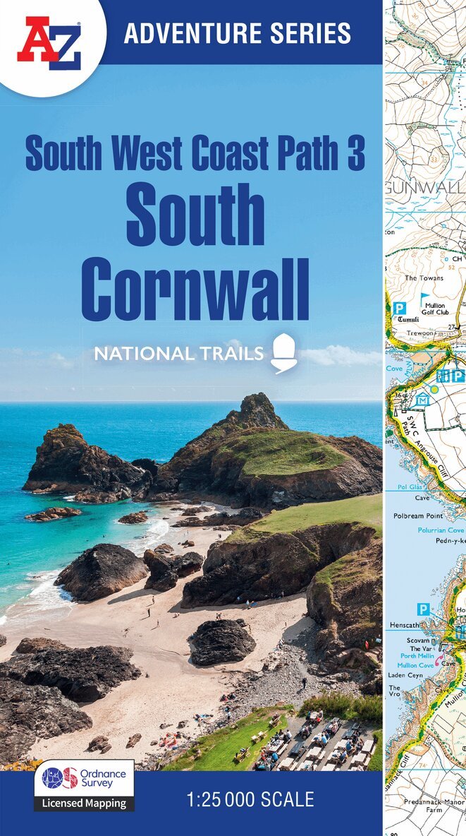
Plan your next adventure along the South Cornwall section of the South West Coast Path with trusted mapping from A-ZThe perfect companion for those wanting to explore the iconic route as seen in The Salt Path, the A-Z Adventure Series features 1:25 000 Ordnance Survey mapping in a convenient book, complete with index.The South West Coast Path is a National Trail along the Somerset, Devon, Cornwall and Dorset coasts. This stunning walk from Minehead, Somerset covers 630 miles to South Haven Point in Poole Harbour, passing through two World Heritage Sites (the Jurassic Coast and the Cornwall and West Devon Mining Landscape), Exmoor National Park, Land's End and many areas of outstanding natural beauty.A series of five A-Z Adventure Atlases together cover the South West Coast Path: South West Coast Path: North Devon and Somerset (9780008707651)South West Coast Path: North Cornwall (9780008707620)South West Coast Path: South Cornwall (9780008707637) South West Coast Path: South Devon (9780008707644)South West Coast Path: Dorset (9780008707668)This A-Z Adventure Atlas of the South West Coast Path: South Cornwall features 50 pages of continuous Ordnance Survey mapping covering the route from Land's End to Plymouth. The trail is easy to follow, highlighted in yellow to stand out from other footpaths, with mileage markers to gauge distances when planning your own sections of the walk to enjoy.The book includes a route planner showing distances between places and indicates available amenities, including: Information CentresVisitor CentresHotels/B&BsYouth HostelsCampsites (seasonal opening)Public HousesShopsRestaurantsCafes (seasonal opening)Petrol stationsOther National Trails available within the A-Z Adventure Series include: Peak District (Dark Peak), Cotswold Way, Peddars Way and Norfolk Coast Path, Pembrokeshire Coast Path, North Coast 500 and South Downs Way.
Häftad, Engelska, 2025
151 kr
Skickas
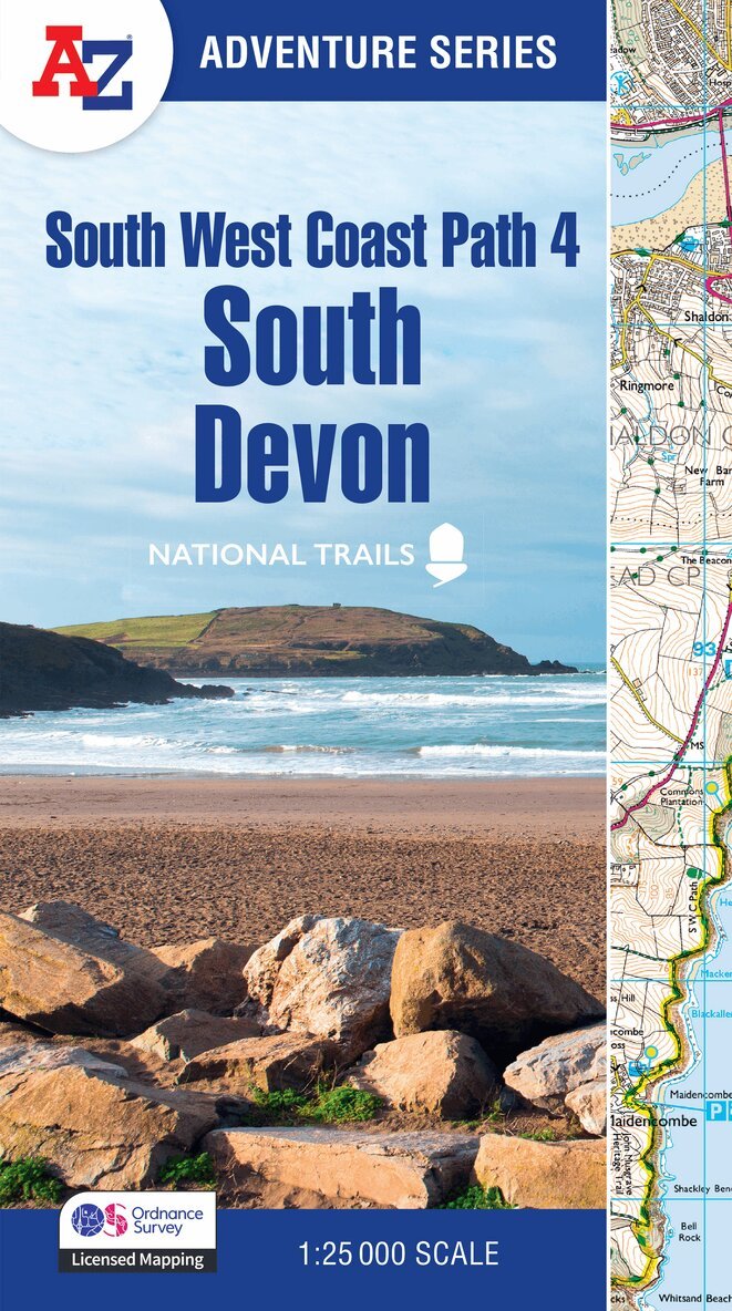
Plan your next adventure along the South Devon section of the South West Coast Path with trusted mapping from A-ZThe perfect companion for those wanting to explore the iconic route as seen in The Salt Path, the A-Z Adventure Series features 1:25 000 Ordnance Survey mapping in a convenient book, complete with index.The South West Coast Path is a National Trail along the Somerset, Devon, Cornwall and Dorset coasts. This stunning walk from Minehead, Somerset covers 630 miles to South Haven Point in Poole Harbour, passing through two World Heritage Sites (the Jurassic Coast and the Cornwall and West Devon Mining Landscape), Exmoor National Park, Land's End and many areas of outstanding natural beauty.This A-Z Adventure Atlas of the South West Coast Path: South Devon features 50 pages of continuous Ordnance Survey mapping covering the route from Plymouth and following the route east to Lyme Regis. The trail is easy to follow, highlighted in yellow to stand out from other footpaths, with mileage markers to gauge distances when planning your own sections of the walk to enjoy.The book includes a route planner showing distances between places and indicates available amenities, including: Information CentresVisitor CentresHotels/B&BsYouth HostelsCampsites (seasonal opening)Public HousesShopsRestaurantsCafes (seasonal opening)Petrol stationsA series of five A-Z Adventure Atlases together cover the South West Coast Path: South West Coast Path: North Devon and Somerset (9780008707651)South West Coast Path: North Cornwall (9780008707620)South West Coast Path: South Cornwall (9780008707637)South West Coast Path: South Devon (9780008707644) South West Coast Path: Dorset (9780008707668)Other National Trails available within the A-Z Adventure Series include: Peak District (Dark Peak), Cotswold Way, Peddars Way and Norfolk Coast Path, Pembrokeshire Coast Path, North Coast 500 and South Downs Way.
Häftad, Engelska, 2025
151 kr
Skickas
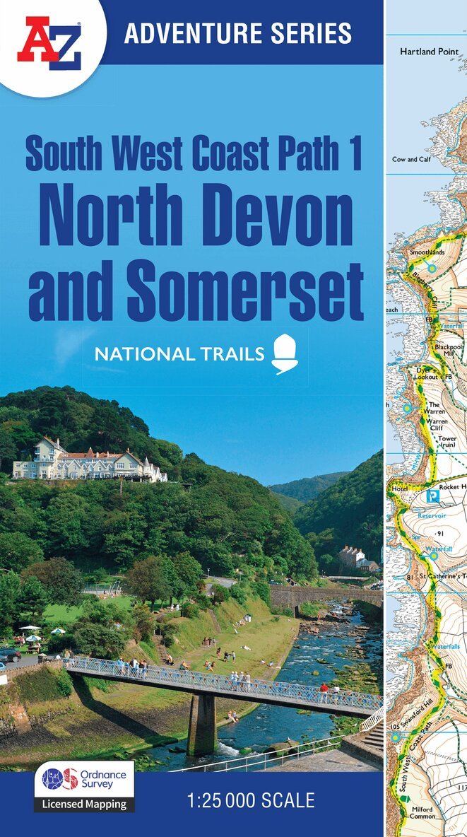
Plan your next adventure along the North Devon & Somerset section of the South West Coast Path with trusted mapping from A-ZThe perfect companion for those wanting to explore the iconic route as seen in The Salt Path, the A-Z Adventure Series features 1:25 000 Ordnance Survey mapping in a convenient book, complete with index.The South West Coast Path is a National Trail along the Somerset, Devon, Cornwall and Dorset coasts. This stunning walk from Minehead, Somerset covers 630 miles to South Haven Point in Poole Harbour, passing through two World Heritage Sites (the Jurassic Coast and the Cornwall and West Devon Mining Landscape), Exmoor National Park, Land's End and many areas of outstanding natural beauty.This guide to the North Devon and Somerset section features 36 pages of continuous Ordnance Survey mapping and covers the South West Coast Path from Minehead to Bude. This atlas includes a route planner providing the distances between places and the amenities available, featuring: Information CentresVisitor CentresHotels/B&BsYouth HostelsCampsites (seasonal opening)Public HousesShopsRestaurantsCafes (seasonal opening)Petrol stationsA series of five A-Z Adventure Atlases together cover the South West Coast Path: South West Coast Path: North Devon and Somerset (9780008707651) South West Coast Path: North Cornwall (9780008707620)South West Coast Path: South Cornwall (9780008707637)South West Coast Path: South Devon (9780008707644)South West Coast Path: Dorset (9780008707668)Other National Trails available within the A-Z Adventure Series include: Cotswold Way, Peddars Way and Norfolk Coast Path, Pembrokeshire Coast Path and South Downs Way.
Häftad, Engelska, 2025
151 kr
Skickas
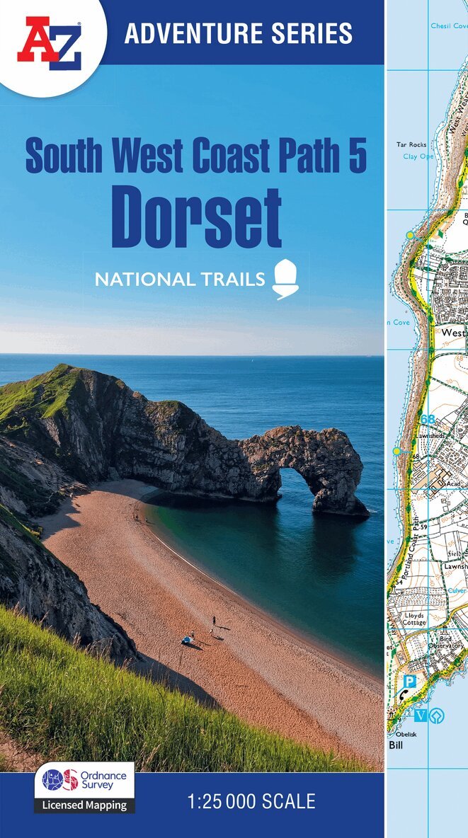
Plan your next adventure along the Dorset section of the South West Coast Path with trusted mapping from A-ZThe perfect companion for those who love the great outdoors, the A-Z Adventure Series features 1:25000 Ordnance Survey mapping in a convenient book, complete with index.The South West Coast Path is a National Trail along the Somerset, Devon, Cornwall and Dorset coasts. This stunning walk from Minehead, Somerset covers 630 miles to South Haven Point in Poole Harbour, passing through two World Heritage Sites (the Jurassic Coast and the Cornwall and West Devon Mining Landscape), Exmoor National Park, Land's End and many areas of outstanding natural beauty.This A-Z Adventure Atlas of the South West Coast Path: Dorset features 36 pages of continuous Ordnance Survey mapping covering the South West Coast Path from Lyme Regis, following the route east, to its finishing point at South Haven Point in Poole Harbour. This atlas includes a route planner providing the distances between places and the amenities available, featuring: Information CentresVisitor CentresHotels/B&BsYouth HostelsCampsites (seasonal opening)Public HousesShopsRestaurantsCafes (seasonal opening)Petrol stationsA series of five A-Z Adventure Atlases together cover the South West Coast Path:•South West Coast Path: North Devon and Somerset•South West Coast Path: North Cornwall•South West Coast Path: South Cornwall•South West Coast Path: South Devon •South West Coast Path: Dorset Other National Trails available within the A-Z Adventure Series include: Peak District (Dark Peak), Cotswold Way, Peddars Way and Norfolk Coast Path, Pembrokeshire Coast Path, North Coast 500 and South Downs Way.
Häftad, Engelska, 2025
146 kr
Skickas
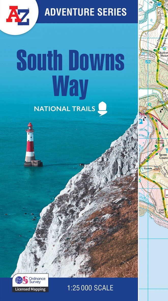
The A-Z Adventure Series uses Ordnance Survey mapping and is the perfect companion for walkers, off-road cyclists, and anyone wishing to explore the great outdoors.Starting in Winchester and finishing in Eastbourne, the scenic South Downs Way is a 100 mile (160 km) National Trail route lying within the South Downs National Park.This National Trail Map features detailed Ordnance Survey mapping at a scale of 1:25 000, providing complete coverage of the South Downs Way. It also includes a route planner showing distances between places and the amenities available to make it easy to plan your adventure. Additional features include: Campsites (seasonal opening)Information CentresHotels/B&BsYouth HostelsPublic HousesShopsRestaurantsCafes (seasonal opening)Petrol StationsOther books available in the A-Z Adventure series include: Peak District (Dark Peak), Cotswold Way, Peddars Way and Norfolk Coast Path, Pembrokeshire Coast Path, South West Coast Path and The North Coast 500.
Häftad, Engelska, 2025
151 kr
Skickas
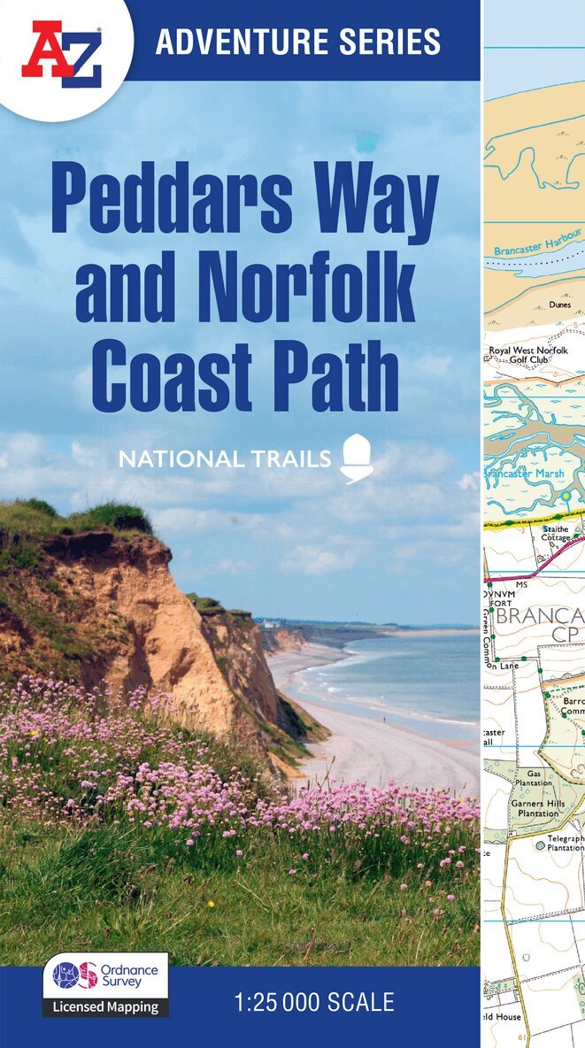
The A-Z Adventure Series uses Ordnance Survey mapping and is the perfect companion for walkers, off-road cyclists, and anyone wishing to explore the great outdoors.Together, Peddars Way and the Norfolk Coast Path form a 93 mile (150km) National Trail across west Norfolk and along its northern coast. The route is clearly shown on the map and passes through a rich landscape with fantastic scenery, places of interest, and an abundance of wildlife.This National Trail Map features detailed Ordnance Survey mapping at a scale of 1:25 000, providing complete coverage of Peddars Way and the Norfolk Coast Path. There is also a route planner included to show distances between places and the amenities available making it easy to plan your adventure. Additional features include: Information CentresHotels/B&BsYouth HostelsCampsites (seasonal opening)Public HousesShopsRestaurantsCafes (seasonal opening)Petrol StationsOther books available in the A-Z Adventure series include: Peak District (Dark Peak), Cotswold Way, South Downs Way, Pembrokeshire Coast Path, South West Coast Path and The North Coast 500.
Häftad, Engelska, 2025
151 kr
Skickas
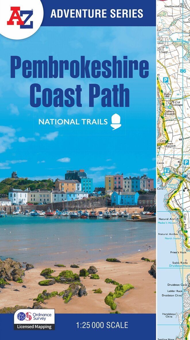
The A-Z Adventure Series uses Ordnance Survey mapping and is the perfect companion for walkers, off-road cyclists, and anyone wishing to explore the great outdoors.The Pembrokeshire Coast Path is a 186 mile (299 km) National Trail in south-west Wales. From Amroth in the south to St Dogmaels in the north and running mainly through the Pembrokeshire National Park, the route passes through some of the most scenic parts of Wales.This National Trail Map features detailed mapping at a scale of 1:25 000, providing complete coverage of the Pembrokeshire Coast Path. There is also a route planner included to show distances between places and the amenities available making it easy to plan your adventure. Additional features include: Information CentresHotels/B&BsYouth HostelsCampsites (seasonal opening)Public HousesShopsRestaurantsCafes (seasonal opening)Petrol StationsOther books available in the A-Z Adventure series include: Peak District (Dark Peak), Peddars Way and Norfolk Coast Path, South Downs Way, Cotswold Way, South West Coast Path and The North Coast 500.

Häftad, Engelska, 2027
151 kr
Kommande
The A-Z Adventure Series uses Ordnance Survey mapping and is the perfect companion for walkers, off-road cyclists, and anyone wishing to explore the great outdoors.The Coast to Coast Walk (C2C) is one of the most popular long distance footpaths in the UK. Devised by Alfred Wainwright, the 180 mile (290km) route starts at St. Bees, on the Irish Sea coast in Cumbria, and passes through three National Parks (the Lake District, Yorkshire Dales, and North York Moors) to finish at Robin Hood's Bay on the North Sea coast.This map features detailed Ordnance Survey mapping at a scale of 1:25 000, providing complete coverage of the Coast to Coast Walk. There is also a route planner included to show distances between places and the amenities available making it easy to plan your adventure. Additional features include: Information CentresHotels/B&BsYouth HostelsCampsites (seasonal opening)Public HousesShopsRestaurantsCafes (seasonal opening)Petrol StationsOther walks available in the A-Z Adventure series include: Cotswold Way, Peddars Way and Norfolk Coast Path, Pembrokeshire Coast Path, South Downs Way and The North Coast 500.
Häftad, Engelska, 2025
151 kr
Skickas
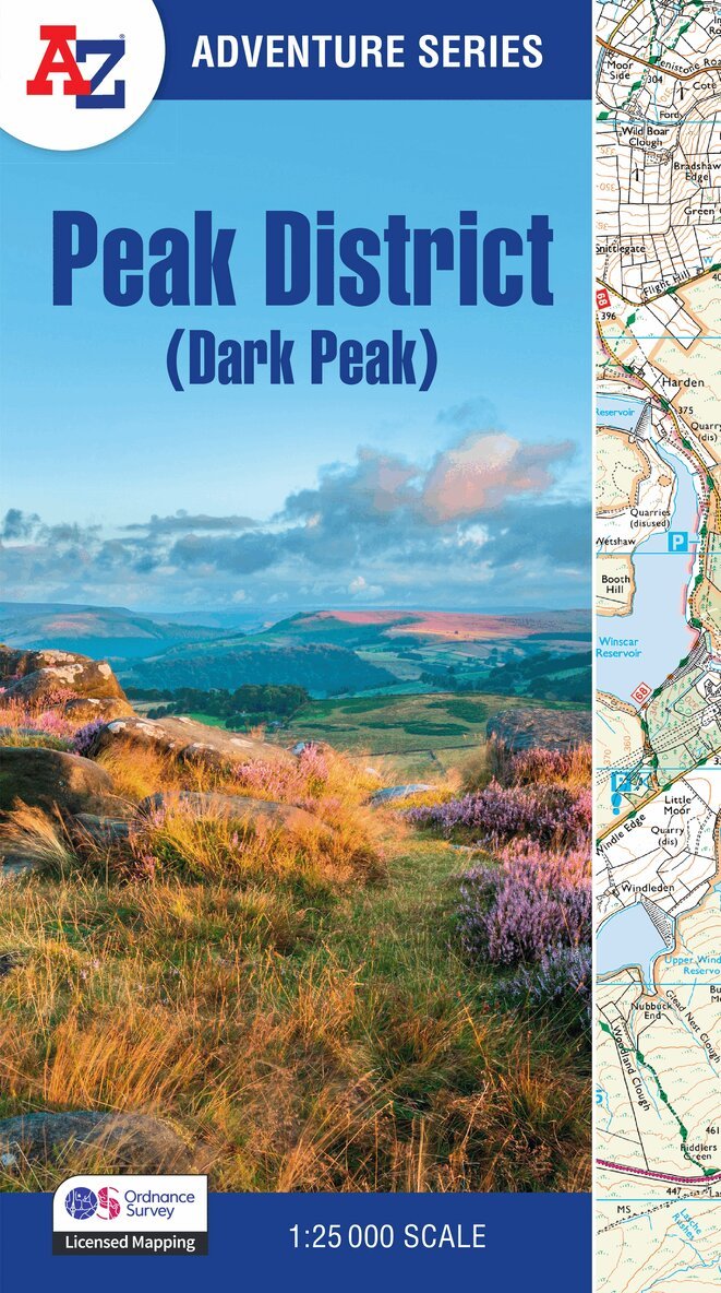
The A-Z Adventure Series uses Ordnance Survey mapping and is the perfect companion for walkers, off-road cyclists, and anyone wishing to explore the great outdoors.This A-Z Adventure Atlas of the Peak District (Dark Peak) features 50 pages of continuous Ordnance Survey mapping covering: Peak District National Park (northern part)Kinder ScoutHope ValleyHathersageCastletonSnake PassDerwent ValleyThis National Trail Map features detailed mapping at a scale of 1:25 000, providing complete coverage of the Peak District (Dark Peak). Additional features include: Information CentresHotels/B&BsYouth HostelsCampsites (seasonal opening)Public HousesShopsRestaurantsCafes (seasonal opening)Petrol StationsOther books available in the A-Z Adventure series include: Pembrokeshire Coast Path, Peddars Way and Norfolk Coast Path, South Downs Way, Cotswold Way, South West Coast Path and The North Coast 500.
Häftad, Engelska, 2026
146 kr
Skickas
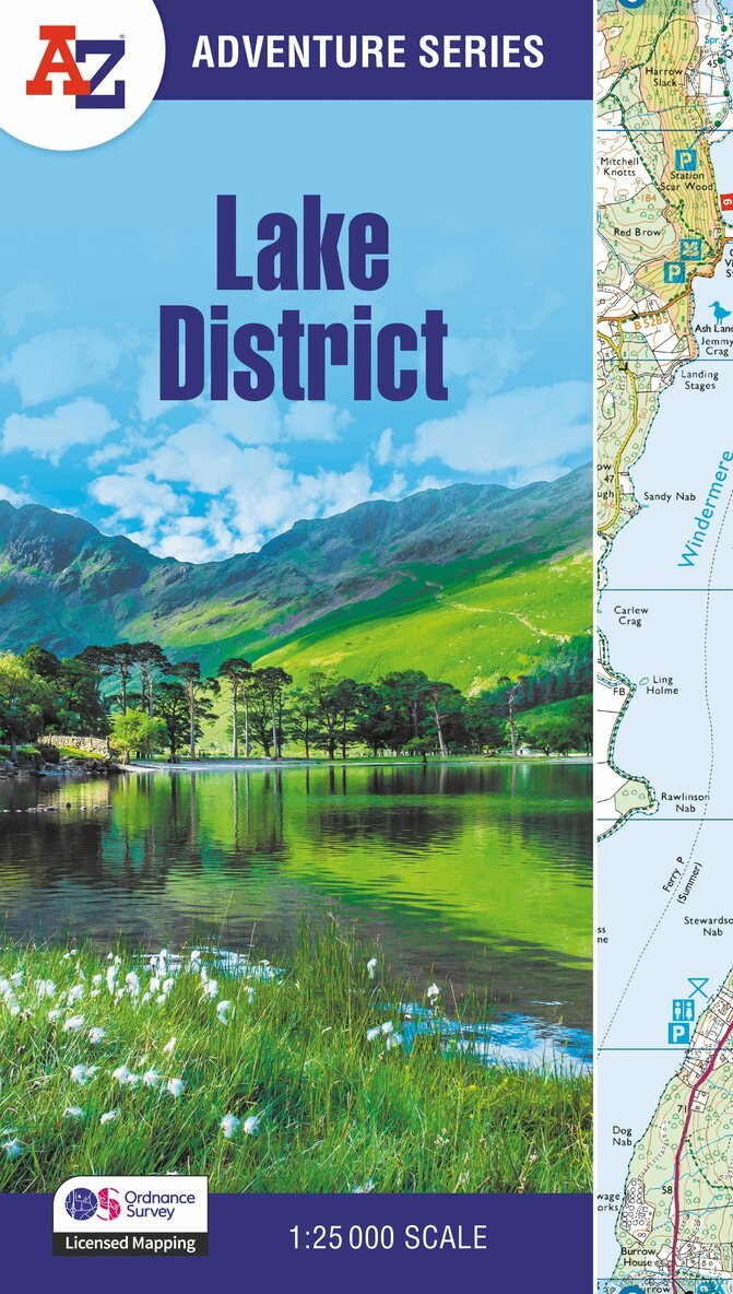
The A-Z Adventure Series of maps combines the best of OS and A-Z, creating the perfect companion for walkers, off-road cyclists, horse riders and anyone wishing to explore the great outdoors.The Lake District is a National Park and a UNESCO World Heritage Site in northwest England. It is a region rich in natural beauty with breathtaking views of striking lakes and stunning mountains, including England's deepest lake (Wastwater) and highest mountain (Scafell Pike). It is no surprise that walkers are drawn here to experience the many and varied routes available, from low-level walking to long hikes into the mountains, as well as the many other activities and attractions.This A-Z Adventure Atlas of the Lake District features 76 pages of continuous Ordnance Survey 1:25 000 mapping covering the popular core area of the National Park with all the notable lakes and celebrated Lakeland fells in a single publication. Unlike original OS sheets, there is a comprehensive index to towns, villages, hamlets and locations, natural features, nature reserves, car parks and youth hostels. Each index entry has a page reference and a six figure National Grid Reference. With a book size of 240mm x 134mm, it is the same size as the standard folded OS map.Other National Trails available within the A-Z Adventure series: Coast to Coast, Cotswold Way, Pembrokeshire Coast Path, South Downs Way, and SW Coast Path.
Häftad, Engelska, 2026
151 kr
Skickas
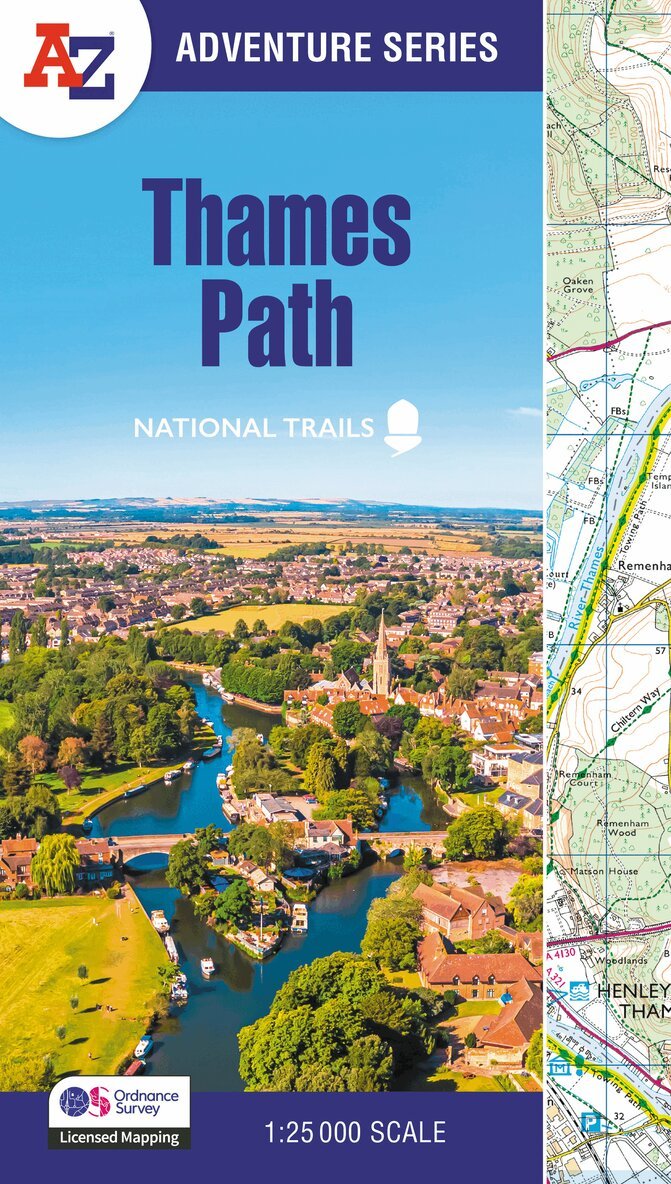
The A-Z Adventure series features the accuracy and quality of Ordnance Survey's 1:25000 mapping in a convenient book, therefore eliminating the need to fold and re-fold a large sheet map to the desired area.OS 1:25 000 is Ordnance Survey's most detailed mapping, showing public rights of way, open access land, national parks, tourist information, car parks, public houses and camping and caravan sites.The Thames Path is a National Trail which covers 298km (185 miles) and follows the length of Englands longest river, the Thames, from its source in the Cotswolds to the Thames Barrier in Greenwich, London.This A-Z Adventure Atlas of the Thames Path features 61 pages of continuous Ordnance Survey mapping providing complete coverage of the Thames Path. Clearly highlighted in yellow, the route is easy to identify and shows both north and south bank alternatives. In addition mileage markers have been introduced to the map making it easy to gauge distances when planning your own sections of the walk to enjoy.A route planner is also included providing distances between places and the amenities available, featuring: Information CentresHotels/B&BsYouth HostelsCampsites (seasonal opening)Pubs, shops, restaurants, and cafes (seasonal opening)Petrol StationsAlso featured is advice on safety and security when walking and details of Tourist Information Centres.This A-Z Adventure Atlas has the accuracy and quality of OS 1:25000 mapping indexed within a book, making it the perfect companion for walkers, off-road cyclists, horse riders and anyone wishing to explore the great outdoors.Other National Trails available within the A-Z Adventure series: Coast to Coast, Cotswold Way, Pembrokeshire Coast Path, South Downs Way, and SW Coast Path.
Häftad, Engelska, 2026
151 kr
Skickas
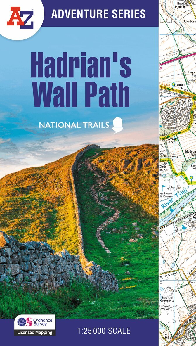
The A-Z Adventure Series of maps combines the best of OS and A-Z, creating the perfect companion for walkers, off-road cyclists, horse riders and anyone wishing to explore the great outdoors.Hadrian's Wall Path is a National Trail which follows the line of Hadrian's Wall from coast-to-coast. The 84 mile (135km) path weaves through beautiful countryside, encountering historic remains of Roman forts and milecastles, splendid bridges, views from the Whin Sill escarpment and Solway salt marshes. Starting in Wallsend in Newcastle and ending in Bowness-on-Solway, the route on the map is clearly highlighted in yellow with mileage markers added to gauge distances when planning sections of the walk to enjoy.This National Trail Map of Hadrian's Wall Path features 38 pages of continuous Ordnance Survey 1:25 000 mapping, providing complete coverage of the Hadrian's Wall Path. The atlas includes a route planner showing distances between places and the amenities available, featuring:•Information Centres•Hotels/B&Bs•Youth Hostels•Campsites (seasonal opening)•Pubs, shops, restaurants, and cafes (seasonal opening)•Petrol StationsAlso featured is advice on safety and security when walking and the Countryside Code.Unlike the original OS sheets, this A-Z Adventure Atlas includes a comprehensive index to towns, villages, hamlets and locations, natural features, nature reserves, car parks and youth hostels, making it easy to find the required location quickly. Each index entry has a page reference and a six figure National Grid Reference. With a book size of 240mm x 134mm it is the same size as the standard folded OS map.Other National Trails available within the A-Z Adventure series include: Cotswold Way, Pembrokeshire Coast Path, South Downs Way, SW Coast Path, and Thames Path.
Häftad, Engelska, 2026
151 kr
Skickas
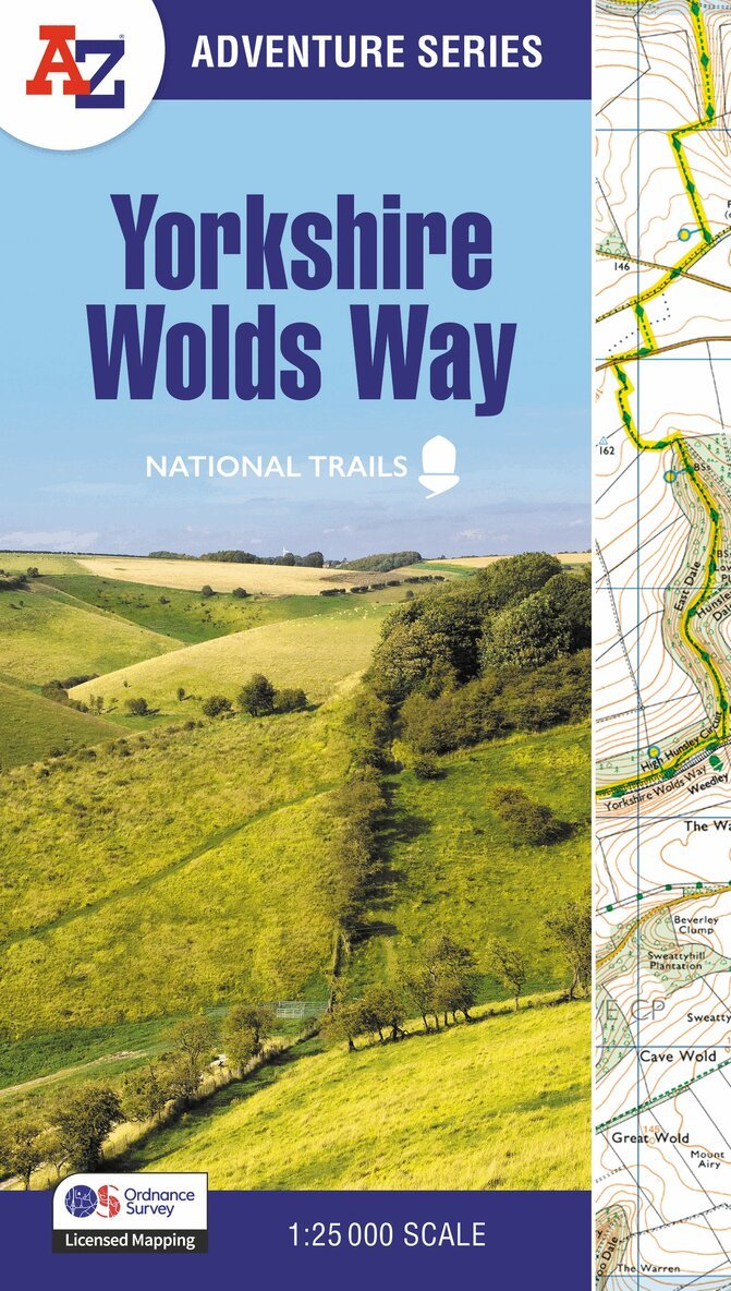
The A-Z Adventure Series of maps combines the best of OS and A-Z, creating the perfect companion for walkers, off-road cyclists, horse riders and anyone wishing to explore the great outdoors.The Yorkshire Wolds Way is a 79 mile (127 km) National Trail from the River Humber to the seaside resort of Filey. Crossing a tranquil landscape, the path encounters gently rolling chalk hills with easy climbs, isolated dry valleys, undulating fields and charming villages. The route on the map is clearly highlighted in yellow with mileage markers to gauge distances when planning sections of the walk to enjoy.This National Trail Map of the Yorkshire Wolds Way features 30 pages of continuous Ordnance Survey 1:25 000 mapping providing complete coverage of the Yorkshire Wolds Way. The atlas includes a route planner showing distances between places and the amenities available, featuring: Information CentresHotels/B&BsYouth HostelsCampsites (seasonal opening)Pubs, shops, restaurants, and cafes (seasonal opening)Petrol StationsAlso featured is advice on safety and security when walking and the Countryside Code.Unlike the original OS sheets, this A-Z Adventure Atlas includes a comprehensive index to towns, villages, hamlets and locations, natural features, nature reserves, car parks and youth hostels, making it easy to find the required location quickly. Each index entry has a page reference and a six figure National Grid Reference. With a book size of 240mm x 134mm it is the same size as the standard OS folded map.Other National Trails available within the A-Z Adventure series include: Cotswold Way, Hadrian's Wall Path, Norfolk Coast Path & Peddars Way, Pembrokeshire Coast Path, Offa’s Dyke Path, South Downs Way, SW Coast Path, and Thames Path.
Häftad, Engelska, 2026
146 kr
Kommande
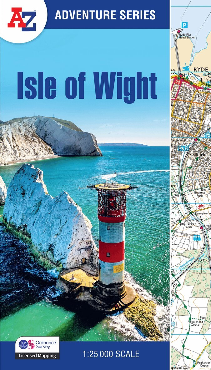
The A-Z Adventure Series of maps combines the best of OS and A-Z, creating the perfect companion for walkers, off-road cyclists, horse riders and anyone wishing to explore the great outdoors.The Isle of Wight is an island off the south coast of England, celebrated for its varied landscapes and coastal beauty. It offers breathtaking views of dramatic cliffs, rolling downs, and sandy beaches, including iconic landmarks such as The Needles and Tennyson Down. It is no surprise that walkers are drawn here to enjoy the many and varied routes available, from gentle coastal strolls to longer hikes across countryside and coastline.This A-Z Adventure Atlas of the Isle of Wight features over 30 pages of continuous Ordnance Survey 1:25 000 mapping covering the entire island. Unlike original OS sheets, there is a comprehensive index to towns, villages, hamlets and locations, natural features, nature reserves, car parks and youth hostels. Each index entry has a page reference and a six figure National Grid Reference. With a book size of 240mm x 134mm, it is the same size as the standard folded OS map.Other National Trails available within the A-Z Adventure series: Cotswold Way, Pembrokeshire Coast Path, South Downs Way, and SW Coast Path.