Fler böcker inom
- Format
- Mixed media product
- Språk
- Engelska
- Antal sidor
- 1
- Utgivningsdatum
- 1995-01-01
- Upplaga
- Facsimile of 1905 ed
- Förlag
- Old House Books
- Illustrationer
- M.(some col.)
- Dimensioner
- 770 x 45 x 45 mm
- Vikt
- Antal komponenter
- 1
- Komponenter
- Contains Sheet map, rolled and Pamphlet
- ISBN
- 9781873590157
- 200 g
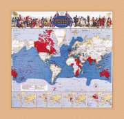
The British Empire Map 1905
A Detailed Colour Map of the Greatest Empire the World Has Ever Seen
Mixed media product,
Engelska, 1995-01-01
Slutsåld
Kundrecensioner
Fler böcker av Edward Allhusen
-

Betrumped
Edward Allhusen
If you think that the English language stays still, carved in tablets of stone, think again. English is constantly on the move, enhancing its scope by gratefully accepting words from other languages. It tolerates changes to meanings, often with hi...
Du kanske gillar
-
Peak Human
Johan Norberg
Häftad -
Peak Human
Johan Norberg
Inbunden -
Face Of Battle
John Keegan
Trade paperback (UK) -
Free Ride
Noraly Schoenmaker
Inbunden -
Nexus
Yuval Noah Harari
Häftad